
No. 1 Moray Place
This is the house where Alexander "Greek" Thomson lived and died. The Thomson family moved into No.1 in 1861, on completion of the initial terrace of 10 houses. The terrace is situated facing the Glasgow - Barrhead Railway line shortly after it splits from the Cathcart Circle line. The Barrhead line was completed in the late 1850's about 35 years before the Cathcart Circle was opened.
Maria Villa, Langside
Alexander Thomson's double villa in Mansion House Road, Langside features a couple of semi-detached houses with a most unusual layout.
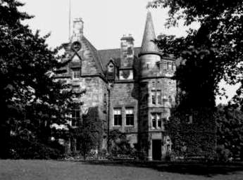
Pollok House
Pollok House, the family home of the Maxwells, was began in 1752.
It was built to designs by William Adam, who had died four years earlier in 1748.
The construction of the house was supervised by his sons, John and Robert Adam.
The side extensions and stables were added at the end of the nineteenth century.
To view historical engravings and modern photographs of Pollok House, you should visit my Pollok Country Park web page.
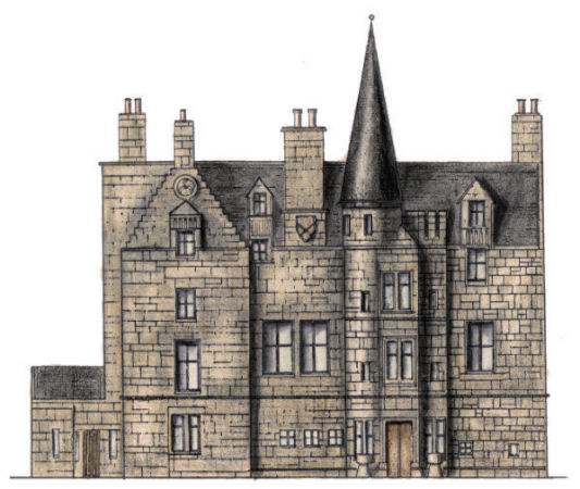
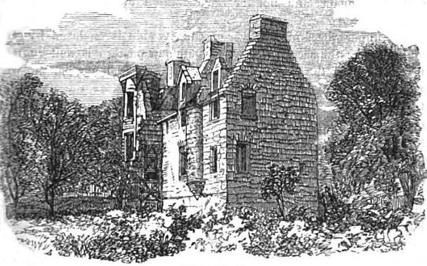
Haggs Castle
The ruins of Haggs Castle, which had been erected in 1585 by Sir John Maxwell, were rebuilt from the remaining walls and vaults between 1860 and 1900 to form the existing structure.
Haggs Castle is situated at 100 St Andrews Drive. The ground to form Maxwell Park, on the opposite side of St Andrew's Drive, was gifted by Sir John Stirling Maxwell in 1888 and the park opened two years later. Victorian engraving of Haggs Castle before it was rebuilt
To find out more about the reconstruction of Haggs Castle and view maps and historic photographs of the surrounding area, you should visit my Pollokshields - Garden Suburb web page.
Map showing castles situated to the south of Glasgow in the mid 1600's.
Haggs Castle, shown as "Hags" at the top of the above map, was just one of many castles or fortified
houses in the area. The largest castle was "Krukstoun" or Crookston Castle. Cathcart Castle and Bogton Castle can be found
on the eastern side of the map.
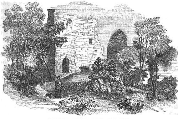
Victorian engraving of Crookston Castle
To find out more about Crookston Castle and the courses of the surrounding rivers and streams, you should visit my South Glasgow Rivers web page.
Pollokshields Library
Pollokshields Library was one of the two Glasgow Carnegie Libraries which was designed "in-house" rather than by a private architect. The other library was Kingston Library, which is part of the Kingston Halls. The plans were prepared by Thomas Gilmour of the Office of Public Works, supervised by the City Engineer & Surveyor, Alexander. B. McDonald. It was built in a version of Rennaisance style which was popular for public buildings at the time.
The library was officially opened on 20th February, 1907 by Sir John Stirling Maxwell, who had donated the site, while the building was funded from Carnegie's millions.
Sir John Maxwell School
Sir John Maxwell School was erected in 1907, shortly before Pollokshaws became part of the city of Glasgow in 1912. Pollokshaws East is the nearest station on the Cathcart Circle to the school. The Glasgow Boundaries Act 1925 saw the city expand further to the south-west of Pollokshaws. Bob Leiser's History of Mansewood site provides images, documents and personal recollections of this little district which became part of Glasgow at that time.
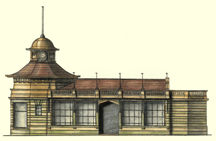
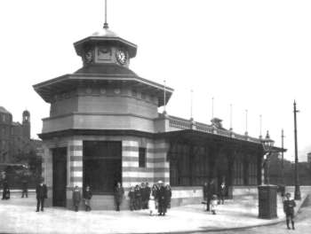
Battlefield Rest
Battlefield Rest at the road junction outside the Victoria Infirmary was built as a transport shelter with a difference! It was planned and built before the general austerity which followed the Great War. The exterior is tiled in the Glasgow Corporation Transport colours of green and cream.
The shelter was opened in 1915 in the heyday of Glasgow's tramcars and was later used by trolleybus passengers in the 1950's and 1960's. There was a news kiosk open to Battlefield Road, which was well used. The interior of the shelter featured a huge mural of Glasgow Corporation Transport. After lying empty and declining into near dereliction, Battlefield Rest was converted into a restaurant in the early 1990's.
Langside Library
Situated across the road from Battlefield Rest is Langside Library, which was the final Carnegie library of Glasgow.The building was completed after the outbreak of the Great War, which marked the end of an era in architectural as well as in many other respects.
Many of the drawings featured in this section of the website were originally exhibited in Langside Library, which has a large reading room suitable for exhibitions. My 'Landmarks of Literacy' exhibition for the City of Architecture also was shown here before moving on to the Mitchell Library and the Andrew Carnegie Birthplace Museum in Dunfermline.
The library was officially opened on 3rd February, 1915 by the Lord Provost, Thomas Dunlop.
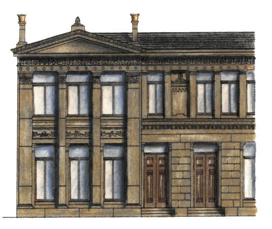
The upper windows of the houses are deeply inset into the façade behind the regular stone mullions, which have oriental motifs inscribed into the stonework.The end bays, at No.1 and No.10, are highlighted with grand pediments which again are adorned with exotic carvings.
There are later terraces adjoining the original, built in the 1860's and 1870's, but they are lacking Thomson's design genius.
Pollokshields West is the nearest station on the Cathcart Circle to this building.
The design follows the standard arrangement of houses placed side by side; what is not expected is that the back of each house is placed against the front of the other, so that they not only share identical layouts but also identical elevations to the east and west.
It is perhaps surprising that the most innovative of Thomson's house arrangements never became a fashionable style to be copied. The houses look much grander than other three bedroom semis of the same era, which were built to the conventional pattern.
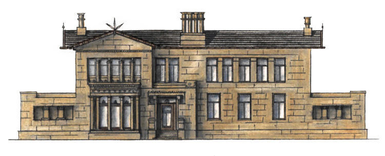
Maria Villa was built in 1857 for Mr Henry Watson who, rather romantically, named his home after his wife, Maria.
Langside is the nearest station on the Cathcart Circle to this building.

The house is situated in the middle of the extensive grounds of Pollok Country Park, in a setting befitting an aristocratic family seat. It was in the ownership of the City of Glasgow from 1966 until being taken over by the National Trust for Scotland in 1998.
The house is open to the public and has a postal address of 2060 Pollokshaws Road, even though it is nearly a mile away from the main road.
Shawlands and Maxwell Park are the nearest stations on the Cathcart Circle to the park, while Pollokshaws West station on the Barrhead line is situated next to the park but still a long way from the house.
The building was used as Glasgow's Museum of Childhood from 1972,
but since 1998 it has been occupied as a 19 roomed dwelling house with a single occupier.
Maxwell Park is the nearest station on the Cathcart Circle to this building.
The land where Maxwell Park is situated was deemed unsuitable for building the large houses which now surround it.
The excess water from the drainage system to dry out the boggy soil led to the creation of the pond, which has been one of the park's main features for over a hundred years.
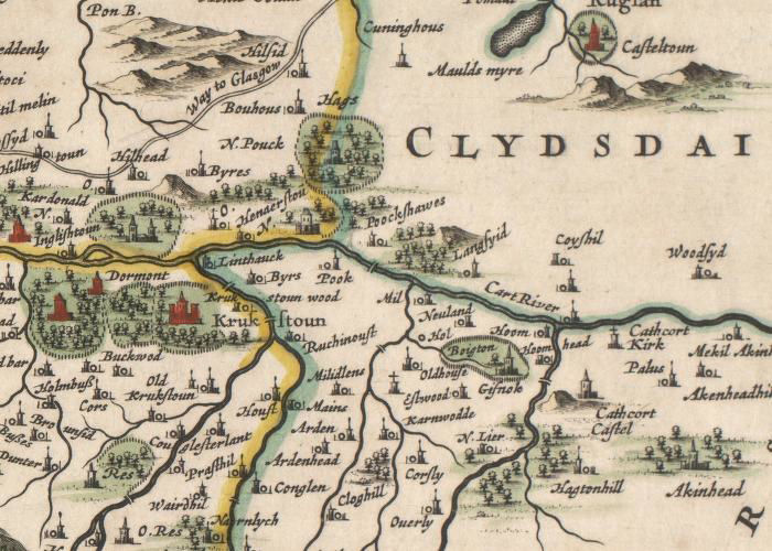
There appears to have been a number of fortified structures to the west of Crookston Castle. These were situated close to
"Dormont" and "Inglishtoun", which were on the way to the more familiar "Kardonald" and "Hillingtoun".
Other place names, familiar as present day suburbs, are "Langsyid", "Poockshawes" and "Coyshil"

Pollokshields (East or West) are the nearest stations on the Cathcart Circle to this building.
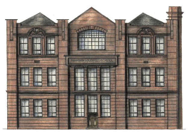
The austere red sandstone frontage has modernistic lettering for the school title carved in the stonework.
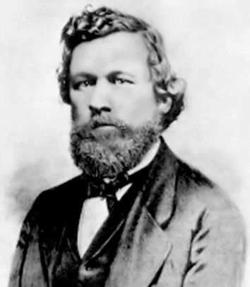
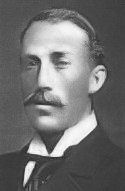
Sir John Stirling Maxwell Bart., M.P. (left) succeeded
to the title and the lands of Pollok in 1878 and was elected as a Member of Parliament in 1895. The land owning aristocracy still had a lot of influence at every level of society at that time.
Langside and Mount Florida are the nearest stations to this building.

The architect was George Simpson who also designed Possilpark Library in the north of the city.
The single storey building features a symmetrical frontage in three bays with the city's coat of arms featured above the central entrance.
Langside and Mount Florida are the nearest stations on the Cathcart Circle to this building.