
The Glasgow district of Castlemilk was at one time the country estate of the Stuarts of Castlemilk, who had connections with the ancient royal family of Scotland.
The estate was acquired by Glasgow Corporation shortly before the outbreak of the Second World War and developed for housing from the late 1950's.
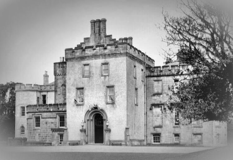
The origins of Castlemilk House, which started out as a fortified tower, are obscured in the distant past.
The oldest part of the house had thick walls, small windows, narrow passages and confined staircases, confirming that its earliest function was as a defensive stronghold.
Later, as a country mansion, Castlemilk House was gradually enlarged and improved to provide a luxurious family residence. The house was neglected while in the ownership of Glasgow Corporation and allowed to fall into a serious state of disrepair before being abandoned and eventually demolished in 1969.
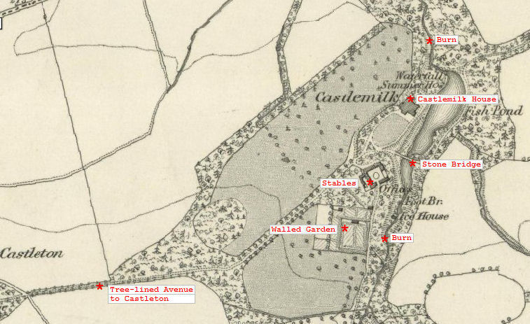
The map below shows the layout of Castlemilk House and the surrounding woodland, gardens and ancilliary buildings in the 1850's. These features had been developed in the previous century.
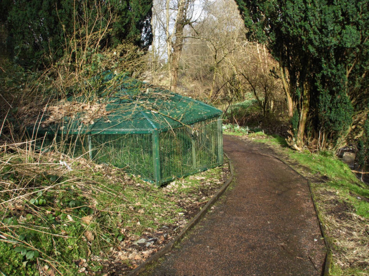
The Ice House shown on the map was used for the preservation of food.
1850's's map showing Castlemilk House with surrounding woodland, gardens, stables and fish pond
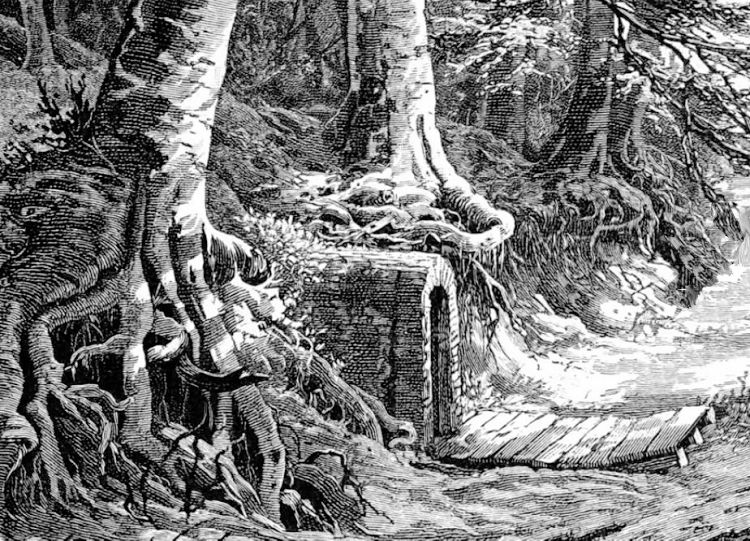
The remains of the entrance to underground "Ice House" shown in the old map are protected by a metal cage
Sketch of entrance to underground ice house
Underground ice houses were commonly situated in the grounds of large estates, close to natural sources of winter ice such as the pond at Castlemilk.
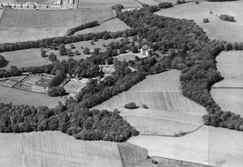
Aerial view of Castlemilk House with surrounding fields, gardens and stables, 1931
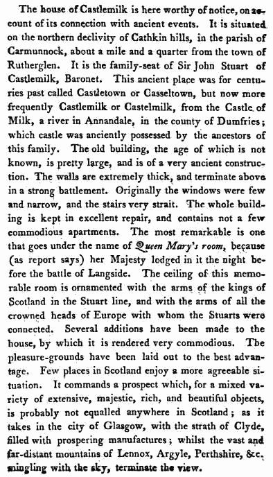
This description of the house and its surroundings comes from 1793, during the tenure of Sir John Stuart, the fifth (and last) Baronet of Castlemilk.
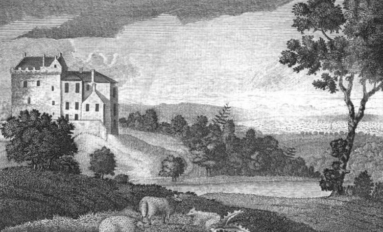
Engraving from 1793 showing Castlemilk House from the south-east with the fish pond in the foreground
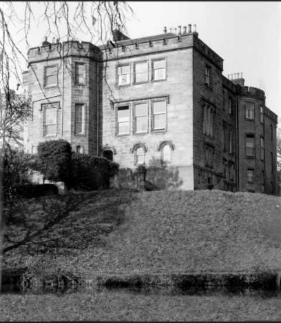
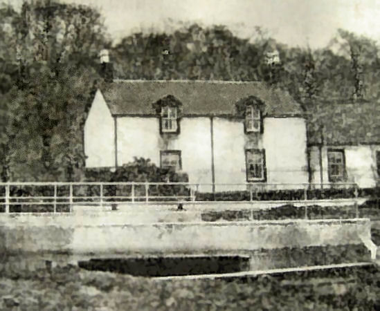
Photograph from 1950's showing Castlemilk House with the fish pond in the foreground
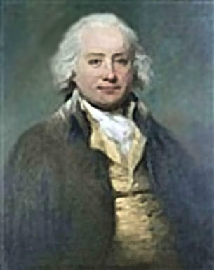
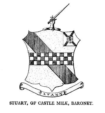
The Stuart Baronetcy, of Castlemilk in the County of Lanark, was created as part of the Baronetage of Nova Scotia on 29 February 1668 for Archibald Stuart. The title became extinct on the death of the fifth Baronet, Sir John Stuart, on 18th January 1797. Portrait and arms of Sir John Stuart, fifth Baronet of Castlemilk
A full list of the Baronets of Castlemilk:
The ratification of the Royal Charter in favour of Sir William Stuart, second Baronet of Castlemilk, on 24th April 1694, refers to "Castlemilk, alias Castleton". It details the lands "lying within the barrony of Carmanock and shirriffdom of Lanerk".
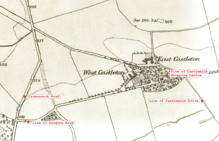
1850's map showing large houses, gardens and gatehouse at Castleton, on site of present day shopping centre
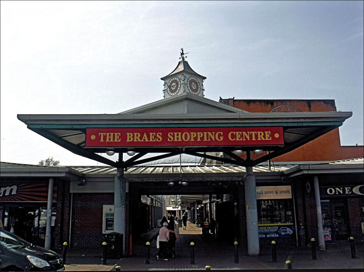
The Braes Shopping Centre, Castlemilk, built on site of the mansions at Castleton
In 1419, during the period of the Hundred Years War, the future King Charles VII of France, who was Dauphin at the time, called on the Scots for help against the English under the terms of the �Auld Alliance�.
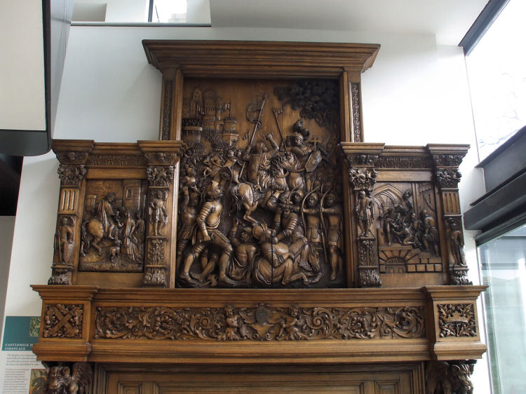
The oak fireplace shown below can be seen at the refurbished Castlemilk Stables. The carved figures recount the Stuart involvement in the the Siege of Orl�ans.
Oak fireplace, recovered from Castlemilk House, depicting the Stuart family's involvement in the Siege of Orl�ans in 1429
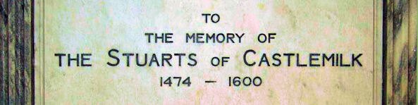
There is evidence to suggest a presence of the Stuarts of Castlemilk at Castleton, Carmunnock as far back as the early 1470's. Plaque from Carmunnock Parish Church dedicated to the Stuarts of Castlemilk 1474-1600
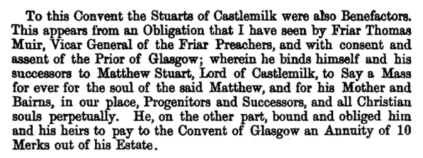
In 1473 the Stuarts of Castlemilk became benefactors of the Dominican 'Friar Preachers', who were based at the Blackfriars Monastery in Glasgow. On the 8th of June 1473, the friars agreed to say Mass in perpetuity for the souls of Matthew, the Laird of Castlemilk, along with his family and decendants, in return for an annuity of 10 Merks.
An illustrated history of the Dominican Order's Blackfriars Monastery can be seen in the
Cathedral Precinct page of this web site. The monastery was destroyed by the Reformers in 1560, but the church survived as as Presbyterian kirk, retaining the name of Blackfriars Church.
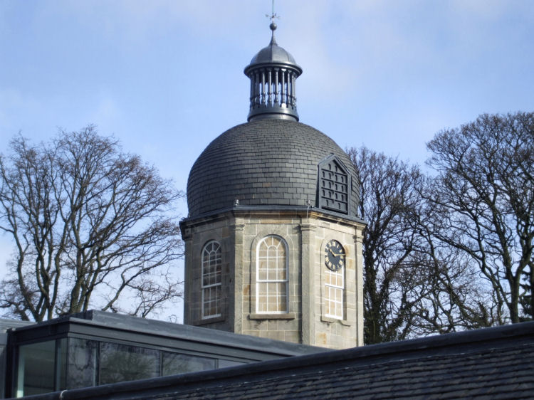
Clock tower at Castlemilk Stables in clear winter sunshine
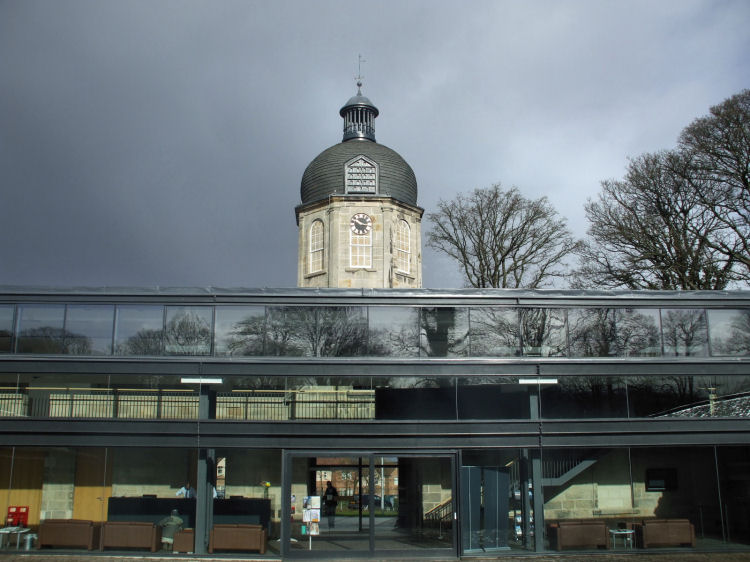
View from central courtyard of newly constructed offices, owned and managed by the Cassiltoun Trust
Original estate offices at rear entrance to stables courtyard, now restored to their original purpose
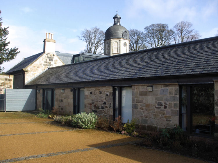
The old stalls at the stables, now full height windows
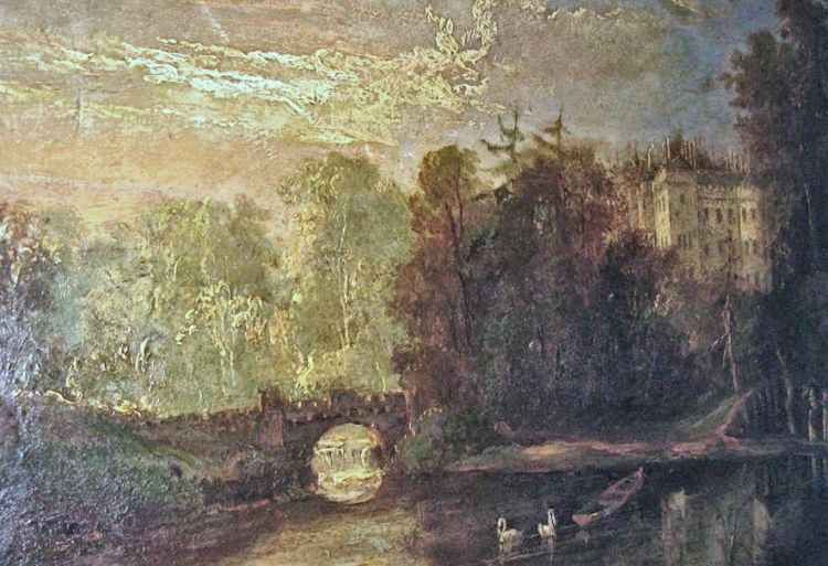
Old painting of swans in pond below Castlemilk House
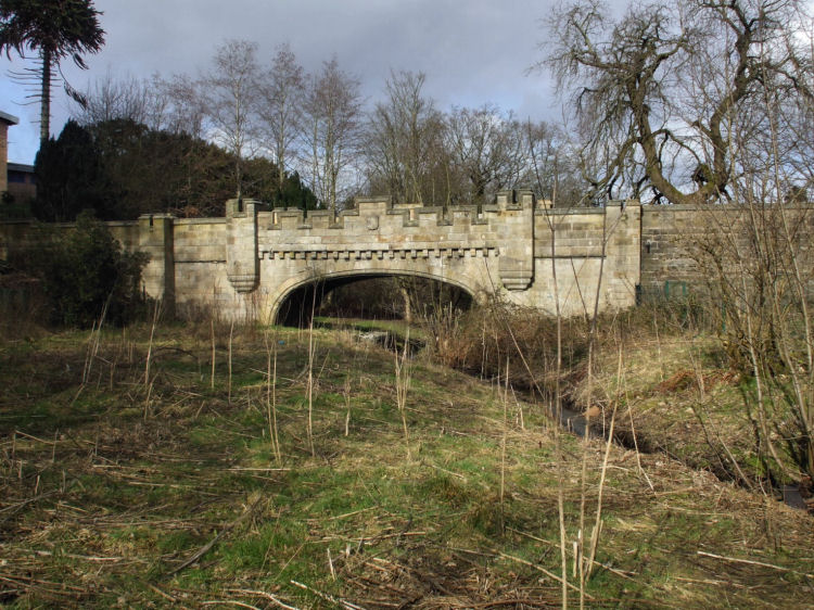
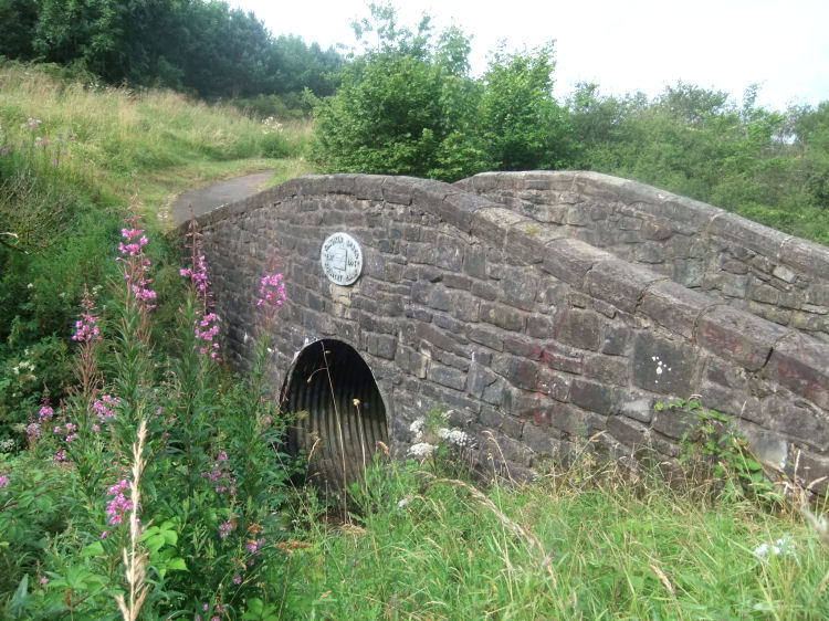
Stone castellated bridge over Castlemilk Burn dating from 1833, refurbished in 2001/2002
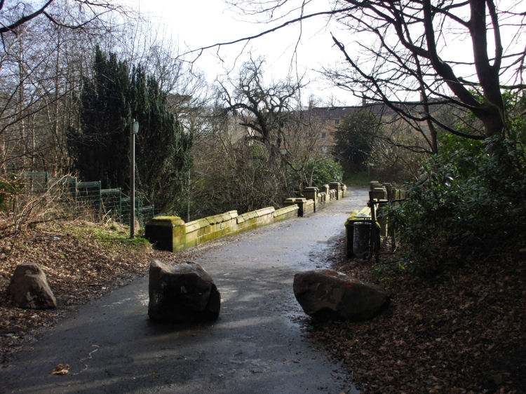
Pathway across the bridge from Castlemilk Stables
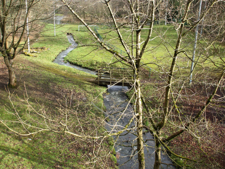
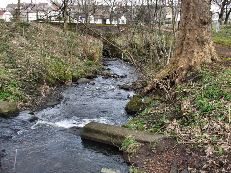
View from stone bridge of Castlemilk Burn flowing towards Fish Pond
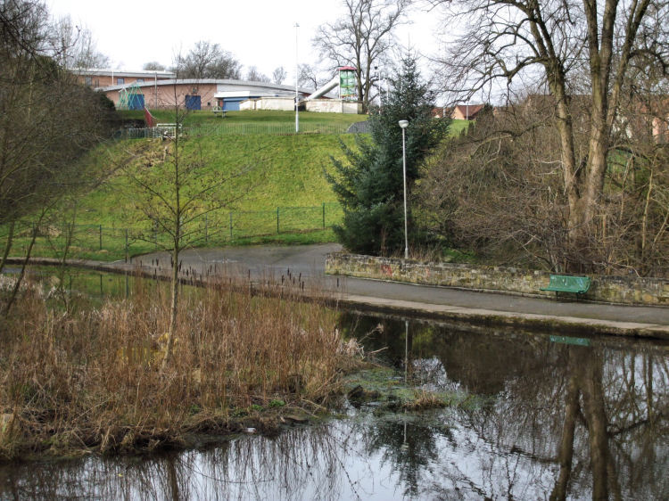
The whitewashed remains of Castlemilk House, on an elevated site overlooking the Fish Pond, can be compared to the 1793 engraving
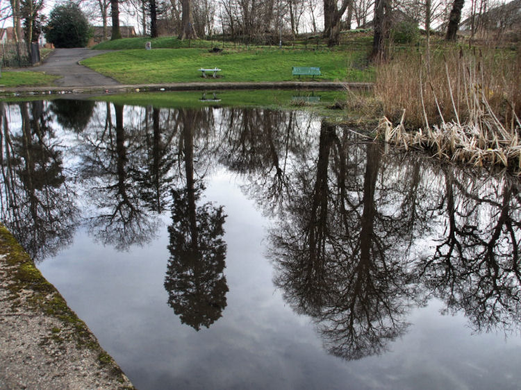
Reflections on Fish Pond at Castlemilk House
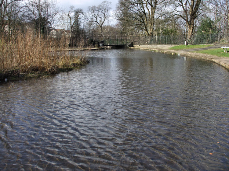
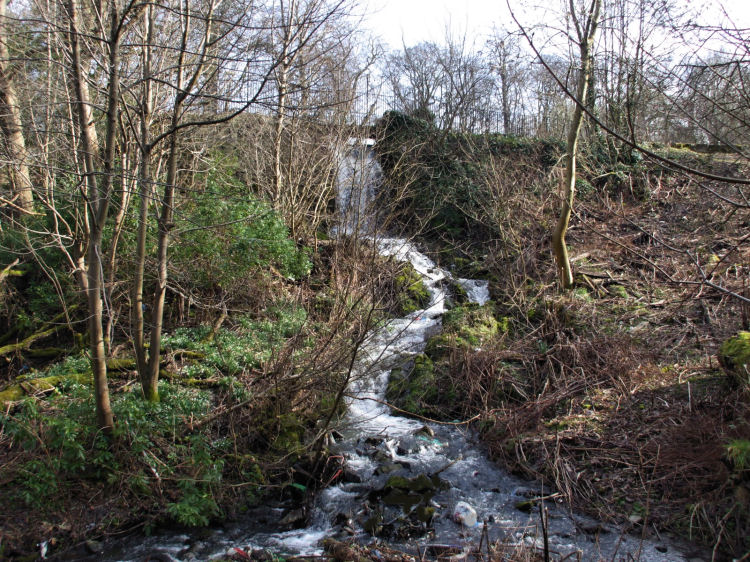
Outflow from Fish Pond to waterfall carrying water down to Castlemilk Burn
Waterfall carrying water from Fish Pond down to Castlemilk Burn
Castlemilk Burn entering culvert at Croftfoot Road before converging with Cityford Burn
Old photograph of burn entering culvert at Croftfoot Farm
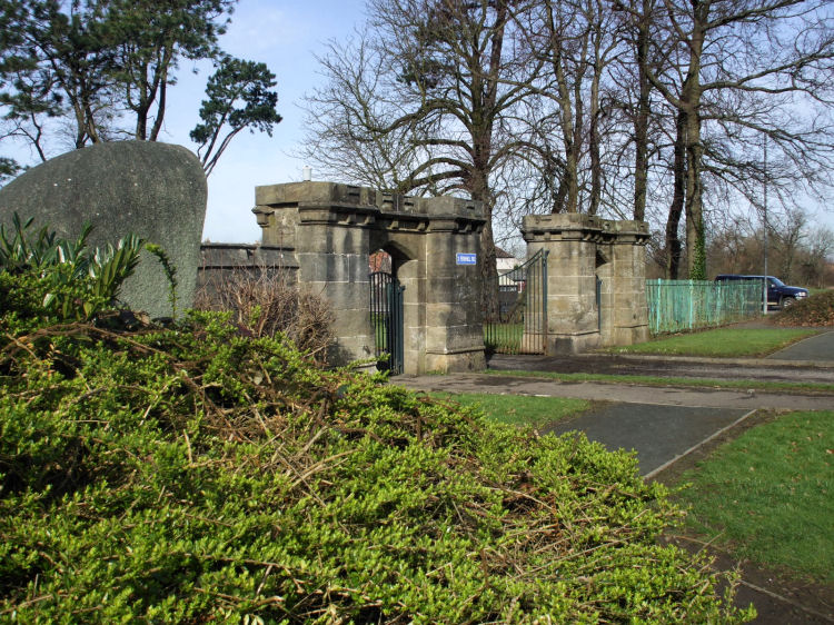
Stone castellated gate piers at eastern entrance to estate
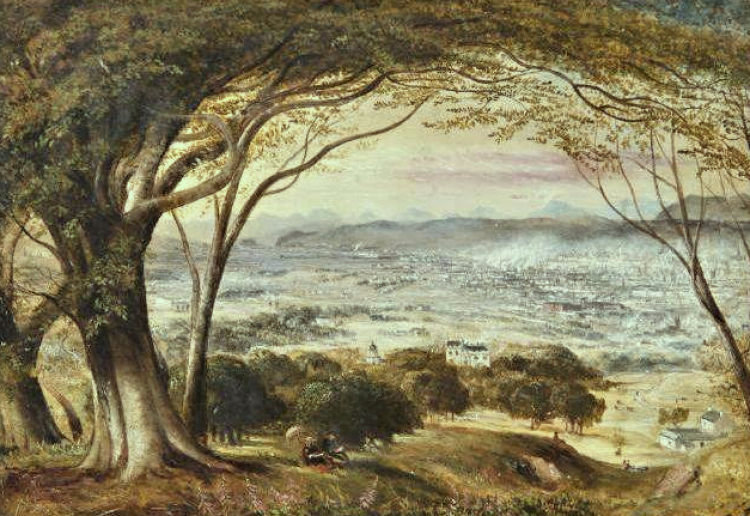
Old view of Castlemilk from Cathkin Braes with City of Glasgow in background
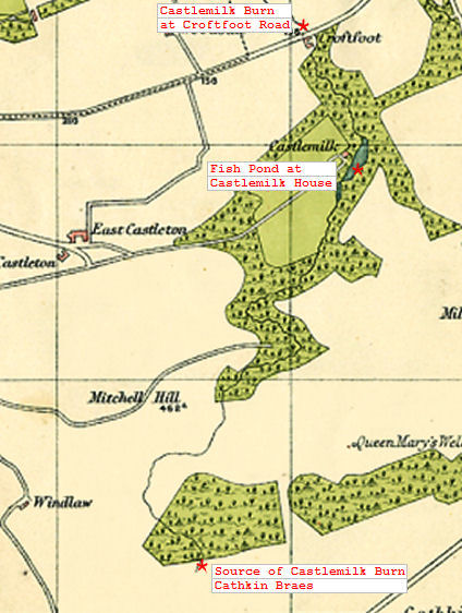
Course of Castlemilk Burn from Cathkin Braes to Croftfoot
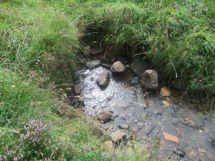
Source of Castlemilk Burn at edge of the "Big Wood" in Cathkin Braes
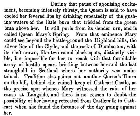
This extract from the "Lifes of the Queens of Scotland", from 1856, gives a very romanticised version of Queen Mary's short and tragic visit to Castlemilk and Cathcart at the time of the Battle of Langside in May 1568. Legend of Queen Mary's Spring, an earlier name for Castlemilk Burn
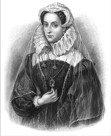
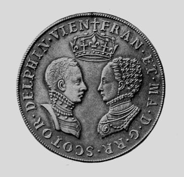
Portrait of Mary Stuart, Queen of Scotland, Queen Consort of France
After the Battle of Langside, the Queen spent the remaining nineteen years of her life as a prisoner of her cousin, Queen Elizabeth of England.
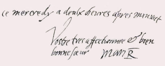
The last letter Of Mary Queen of Scots was written to her brother-in-law, King Henri III of France, on the morning of her execution by beheading on 8th February 1587. It gives a sad insight into her thoughts regarding her long incarceration and being denied the last rites before her imminent death. "Wednesday at two in the morning Your most loving and most true sister Mary R"
This touching letter was written on three pages of paper secured by a narrow piece of ribbon. It shows a firm steady hand which betrays no symptoms of weakness or indecision. The letter remained in the archives of the Scots College in Paris up to the time of the French Revolution. It is now held by the National Library of Scotland.
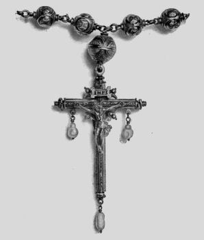
Bridal medal of Mary and Fran�ois and the Queen's Rosary and Crucifix, recovered after her execution
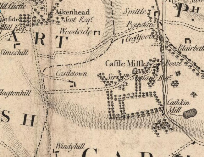
This map from 1795 shows a Mill in the Cathkin Braes powered by the Castlemilk Burn, where downstream you can find "Boose"!
Bridge over Castlemilk Burn at Cathkin Braes carrying pathway down to Ardencraig Road
Recent archaeological excavations in Castlemilk have not produced many interesting finds. Much of the material uncovered was relatively recent, mostly discarded broken pottery from the 18th and 19th centuries.
Castlemilk Hall, Carmunnock, was formally opened on 13th October 1893.
The land had been provided by Mr William Stirling Stuart of Castlemilk and the building was funded by Mr James Graham of nearby Kittochside who wished to provide a public hall and reading room for the residents of the village of Carmunnock.
Early view of Castlemilk Hall, Carmunnock
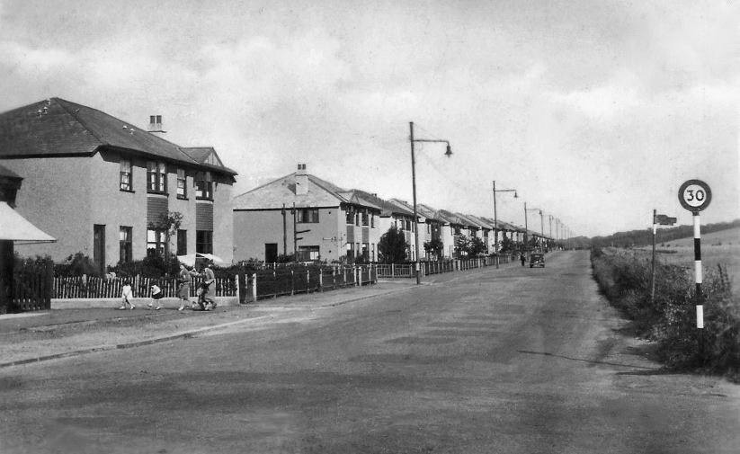
The suburbs of Croftfoot and King's Park were developed in the 1920's and 1930's, before the outbreak of World War II. The fields that would later form the Castlemilk housing scheme were situated immediately south of Croftfoot, as seen in the photograph below showing four-in-a-block housing built to let by the Western Heritable Investment Company.
Croftfoot Road with newly built houses facing the fields of Castlemilk, c. 1938
Eastern end of Croftfoot Road in 1930's
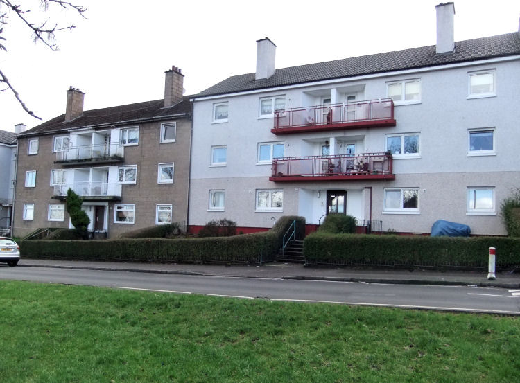
The development of the Castlemilk housing scheme from the 1950's provided homes for those affected by the removal of sub-standard accommodation in many districts of the old city. The main house type were blocks of flats designed as modern versions of traditional Glasgow tenements, entered from common closes.
Original 1950's Castlemilk block alongside renovated block with new roof and rendered walls
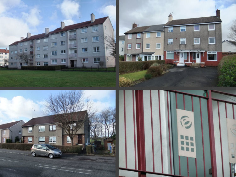
In the initial development of the scheme there were a limited number of house types, some of which are shown below. As well as the common 3 or 4 storey blocks of flats (top left), there were 3-storey terraced houses built for larger families (top right) and 4-in-a-block homes for the local fire service personnel (bottom left). Different house types from initial development of Castlemilk
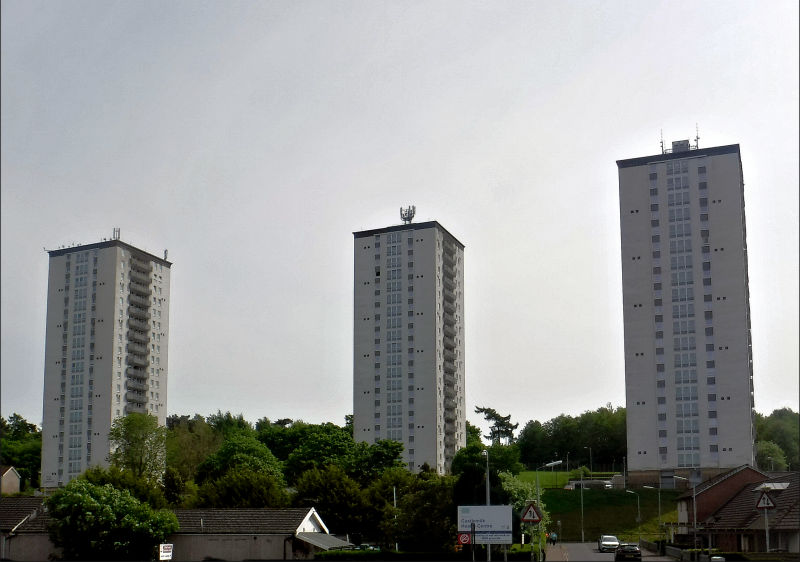
The only surviving multi-storey tower blocks in Castlemilk were completed in 1966 at Dougrie Place, near the newly opened shopping centre. Glasgow's first City Architect, Archibald Jury, was responsible for the three 20 storey blocks shown below.
Multi-storey flats at Dougrie Place, Castlemilk, May 2023
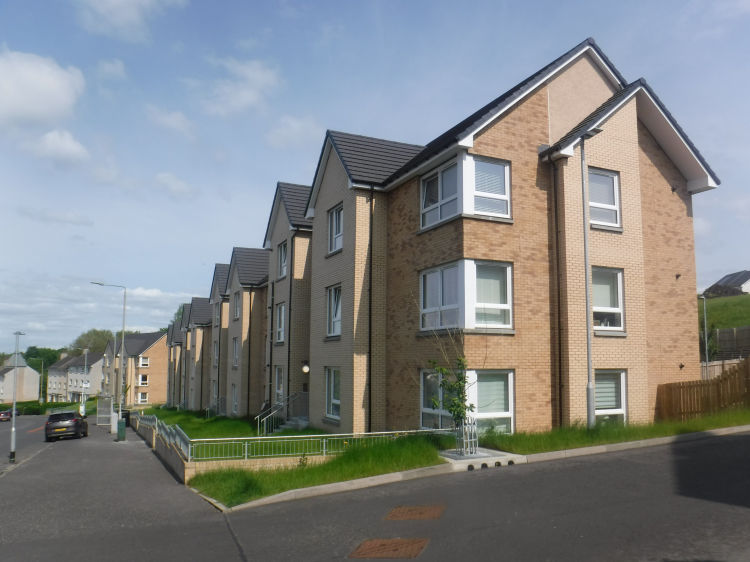
Other multi-storey blocks in Castlemilk dating from the 1960's have been demolished, like many similar developments throughout the city.
Long view of new housing in Castlemilk Drive leading down to 1950's blocks, May 2023
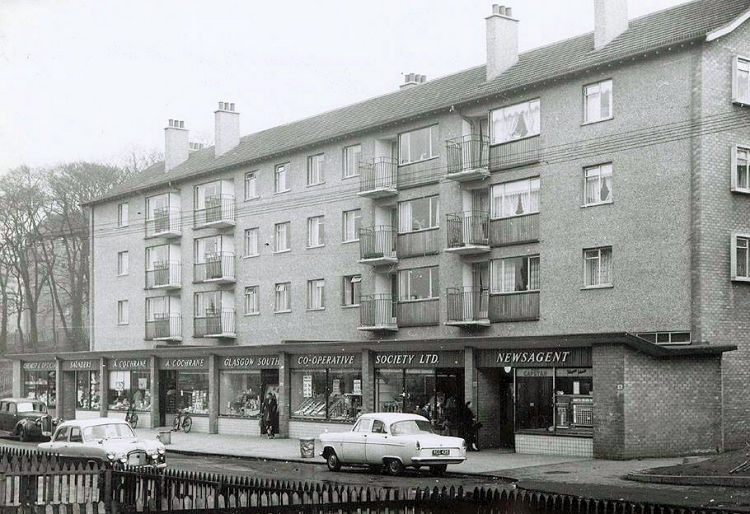
In all of the city's peripheral post-war housing schemes small ranges of shops were provided by Glasgow Corporation. They were situated on the ground level of otherwise standard housing blocks and had identically styled signs on their fascias. The shops were all owned and let by the Corporation to selected tenants, with no licensed premises permitted.
Range of shops in Machrie Road Castlemilk, 1958
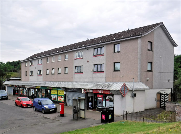
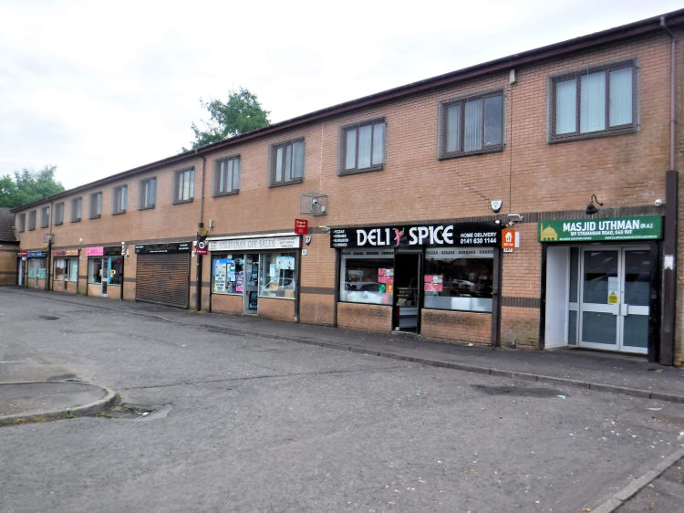
The only surviving 'scheme shops' from the early days of Castlemilk are situated in Tormusk Road and Stravanan Road. The Tormusk Road shops are owned by Wheatley Homes while the Stravanan Road shops are let out by a private landlord.
Range of shops in Tormusk Road Castlemilk, June 2023
Range of shops in Stravanan Road Castlemilk, June 2023
Although the first residents of Castlemilk in the 1950's had to do without pubs and other social amenities, they very soon had places of worship with two Church of Scotland parishes and three Roman Catholic parishes being established within the new housing scheme before the decade was out.
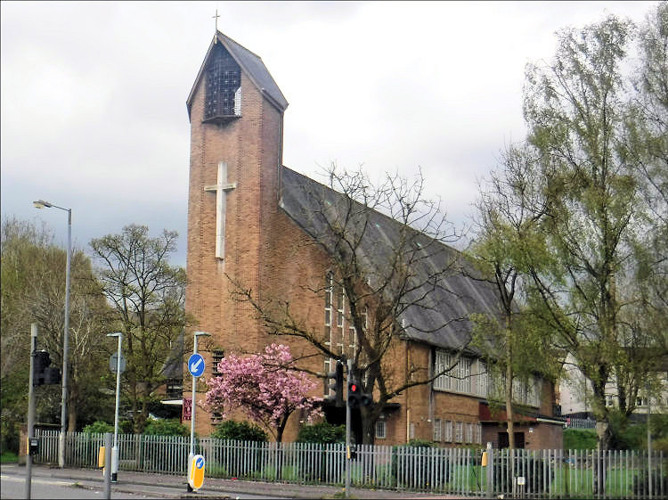
Castlemilk West Church of Scotland was situated in a prominent position on a hillside facing Carmunnock Road. The church was designed by the architectural practice of Gratton and Maclean to provide for for an existing congregation which was established in 1955. It was formally opened on 12th December 1958. Castlemilk West Church
Castlemilk East Church was designed by architect Walter Ramsay and built between 1956 and 1959.
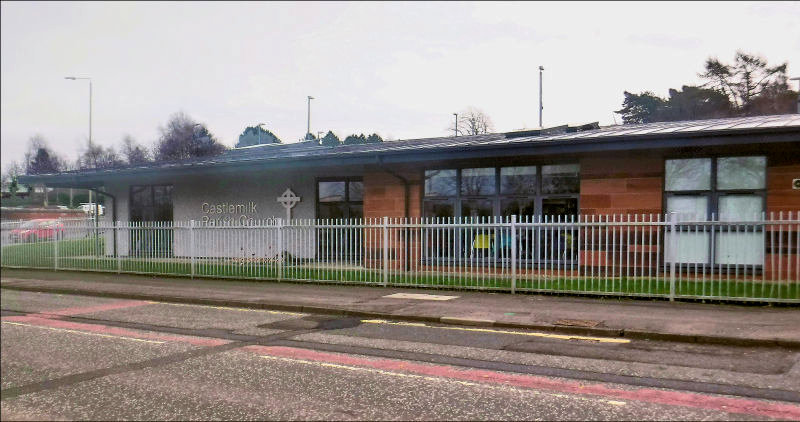
The congregation vacated their building in 2012 and joined up with the members of Castlemilk West Church to form a single Church of Scotland parish for the district, titled simply as Castlemilk Parish.
The new Castlemilk Parish Church, created by the architectural practice of Angus Design Associates, was opened in September 2016. The congregation now occupy a single storey modern building which does not follow the outdated patterns of traditional church design. Castlemilk Parish Church, February 2023
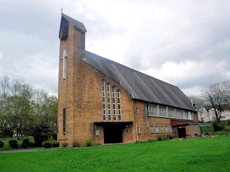
St Margaret Mary's Roman Catholic church, which dates from 1959, is a local landmark situated on a prominent site at the corner of Carmunnock Road and Dougrie Road. The church and adjoining presbytery were designed by Thomas S. Cordiner who made a reputation as a dependable architect for conventional post-war projects for the Archdiocese of Glasgow and other public bodies.
The church was constructed around a reinforced concrete portal frame with a brick infill. The two storey building has a high steeply sloping slated roof and features an attractive central tower with a large cross facing Dougrie Road. The gable walls of the church splay towards the tower which has an ornamental metal screened belfry at its summit. The hall at ground level is entered directly from the entrance porches which provide access to the church on the upper floor via stairwells illuminated by a series of tall stepped windows.
St Margaret Mary's Church, Castlemilk
St Margaret Mary's parish was established in September 1957 and the new church was opened by Archbishop Donald Campbell in December 1959. The first clergy of the new parish in 1957 were Rev. Martin Hughes and a newly ordained curate, Rev Anthony Burke. They were initially based at a house at 17 Downcraig Drive while construction work on the church and presbytery was proceeding. Sunday masses initially took place at Dougrie Terrace School.
St Margaret Mary's Church, Castlemilk
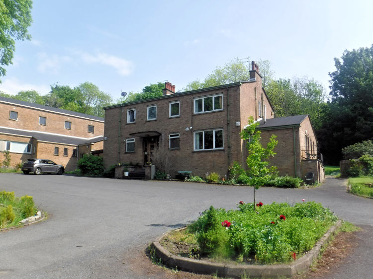
The presbytery of St Margaret Mary's Church is situated to the east of the main building to which it is connected. Although it was built in 1959 its imaginative design still has a modern feel to it with a very steep slated roof over the attic accommodation.
Presbytery at St Margaret Mary's Church, Castlemilk
St Martin's Roman Catholic Parish in Castlemilk was founded in 1957, based in a house at 29 Ballantay Road. Sunday masses initially took place in Ardencraig School and later Glenwood School while the church was being planned and constructed. The new church building and adjacent presbytery were completed in 1961.
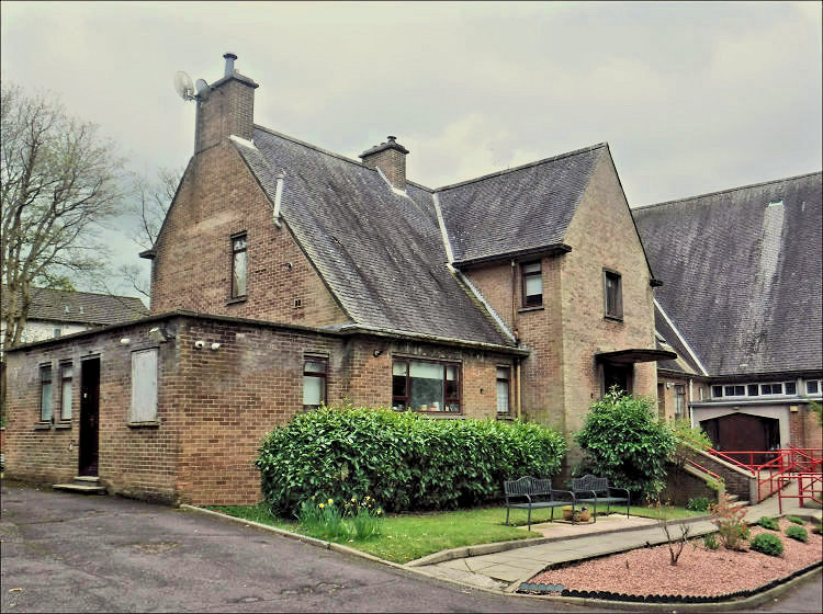
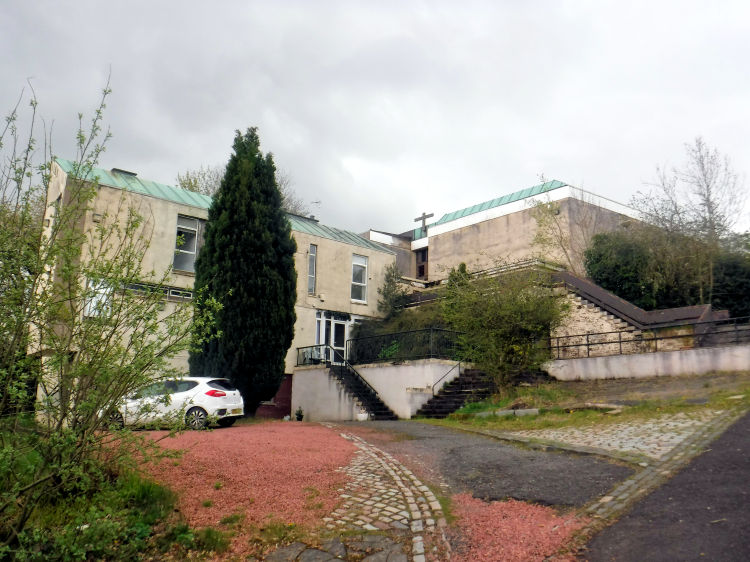
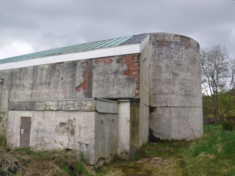
The church was built on the southern side of Ardencraig Rd at the foot of the Cathkin Braes Country Park, surrounded by grassy slopes and trees. It was accessed from a series of terraces and staircases built in to the hillside. Presbytery at St Martin's Church in front of derelict church building, May 2023
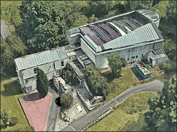
St Martin's Church was designed by the famous architectural practice of Gillespie, Kidd & Coia. It's novel design and poor choice of building materials were to cause many problems in its maintenance. The church was constructed with reinforced concrete and facing brick. The brickwork rapidly deteriorated and had to be rendered within a decade of completion to protect it from the elements. Aerial view of St Martin's Church, Castlemilk
Apse of St Martin's Church, Castlemilk, May 2023
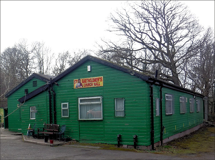
St. Bartholomew's Parish in Castlemilk was established in 1955, providing the earliest Roman Catholic presence in the new housing scheme. The first Parish Priest, Rev. Daniel Toy, occupied a house at 25 Arnprior Road before the presbytery was ready for occupation in 1958.
St. Bartholomew's first services took place in a simple green painted hut which opened in September 1955 and survived as the parish hall after the church opened in April 1958. It remains in good condition having outlasted some of the more permanent church buildings of various denominations which have since gone out of use.
St Bartholomew's Church Hall, Castlemilk
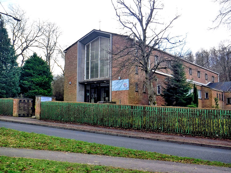
The foundation stone for the new church was laid by the Archbishop of Glasgow, Donald Campbell, on 23rd May 1957. The church, designed by Thomas S. Cordiner, opened in April 1958. St Bartholomew's Church, Castlemilk
Presbytery at St Bartholomew's Church, Castlemilk
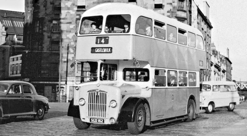
No. 14 Castlemilk bus approaching the St Enoch Square terminus, c.1960
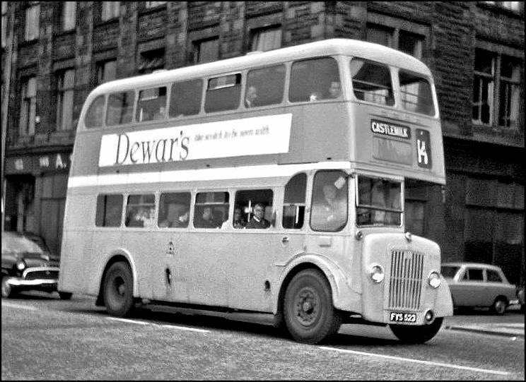
No. 14 Castlemilk bound bus in Clyde Street, c.1966
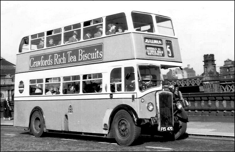
No. 5 Castlemilk bound bus crossing Victoria Bridge, Gorbals, c.1957
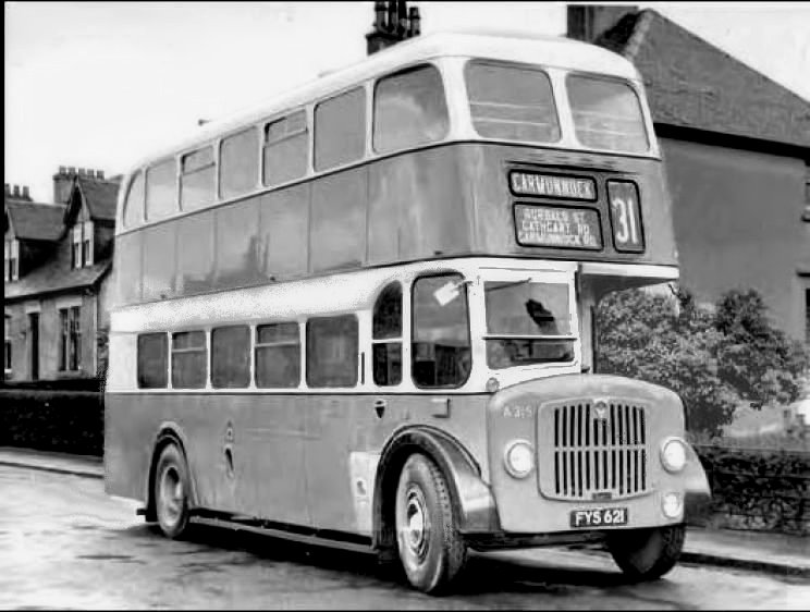
No. 31 Carmunnock bus, c.1955
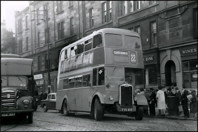
The No. 22 route was introduced to link Castlemilk with Easterhouse, another peripheral housing scheme developed at the same time in the city's east end.
No. 22 Castlemilk bus in the east end of Glasgow, c.1962
After the time of the Scottish wars of independence and the establishment of the Stuart monarchy, the Lands of Castleton (or Cassiltoun) in the parish of Carmunnock came into the possession of the Douglas family. In 1455, following the rebellion of James, ninth (and last) Earl of Douglas, against King James II, all the family titles and estates were forfeited to the Crown. A short time later the confiscated lands at Castleton passed to the Stuarts of Castlemilk, Dumfriesshire. The tower house and surrounding grounds were developed during the remainder of the century. After selling their Dumfriesshire lands in 1579 to the Maxwell family, the Stuarts adopted the name Castlemilk for their estate at Castleton.
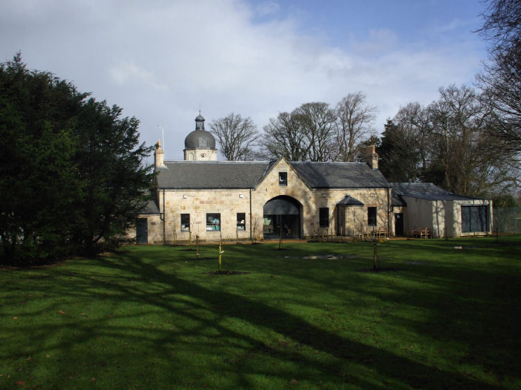
The stables block, which included the estate offices, was added around 1800. Castlemilk Stables, which features a beautiful clock tower, were carefully restored in 2007 to provide modern office space around a central courtyard.
Castlemilk Burn, which rises in the Cathkin Braes, flows through the estate supplying the water for the fish pond. It is crossed by a picturesque stone bridge dating from 1833.
Before the advent of refrigeration technology, they were used to store ice which could be used throughout the year for the storage of foods not preserved by curing or smoking.
It gives details of Queen Mary's Room, where the Queen slept on the eve of the Battle of Langside.
The Baronetage of Nova Scotia was created in 1624 by King James VI, son of Mary Queen of Scots, as a means of financing the settlement of the New World province. The scheme was implemented by his successor, King Charles I, who created the first Scottish baronet in 1625.
A portrait of the fifth Baronet of Castlemilk, Sir John Stuart, is shown below alongside his coat of arms which features the emblem of Nova Scotia in the "sinister canton". When Sir John died without issue in 1797 the title went with him. The estate was then inherited by Andrew Stuart of Torrance, Sir John's nearest male heir.
Sir Archibald Stuart, first Baronet (1668 - 1670)
Sir William Stuart, second Baronet (d. 1715)
Sir Archibald Stuart, third Baronet (d. 1763)
Sir John Stuart, fourth Baronet (d. 1781)
Sir John Stuart, fifth Baronet (d. 1797)
The estate's original name of Castleton was retained for the large houses to the west of Castlemilk House, on the site of the present day shopping centre at Castlemilk Arcade. The old maps show that the two parts of the estate were linked by a tree-lined avenue.
Castleton's later title of Castlemilk had been borrowed from the lands of that name in Dumfriesshire held by the Stuart family, who had re-named the estate after their castle beside the River Mylk (or Milk).
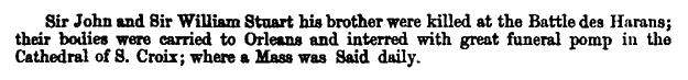
The Stuarts of Castlemilk, Dumfriesshire answered the call and Sir William Stuart of Castlemilk with his brother, Sir John Stuart of Darnley, went over to France to assist Charles against the forces of England and her allies. After the victory at the Battle of Baug� in 1421 the Dauphin rewarded Sir John Stuart with the Lordship and Estate of Aubigny.
Both brothers were killed in February 1429, near to Orl�ans, assisting the army led by Joan of Arc who successfully relieved the prolonged siege of the town.
The family crypt at Carmunnock Parish Church contains a plaque dedicated 'To the 'Memory of the Stuarts of Castlemilk 1474-1600'.
It gives a very pleasant description of the Cathkin Braes and the burn, giving it the title of "Queen Mary's Spring".
The site at Court Knowe, Cathcart, where the Queen watched the Battle of Langside features in my Old Cathcart page.
A full description of the battle can be seen at my Langside page.
The letter was signed just six hours before the Queen's appointment with the axeman at 8am.
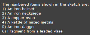
Back in the summer of 1792, however, a number of antiquities dating back to more ancient times were dug up in a field within the Castlemilk estate.
The unearthed archaeological discoveries are shown in the sketch below.
The refurbishment of the flats did not escape the imitation of Glasgow's most famous architect, Charles Rennie Mackintosh, and his stylised rose motif (bottom right).
The Mitchellhill high-rise blocks were situated at the southern edge of Castlemilk in Ardencraig Road, below the Cathkin Braes. The development consisted of five twenty-storey blocks built by George Wimpey Ltd and completed in 1965. The blocks were flattened on 27 November 2005 with a series of controlled explosions.
A single 20 storey tower block was built in 1966 by George Wimpey Ltd at Bogany Terrace. It was the first of Castlemilk's muli-storeys to be demolished when it was destroyed by a controlled explosion on 28 March 1993.
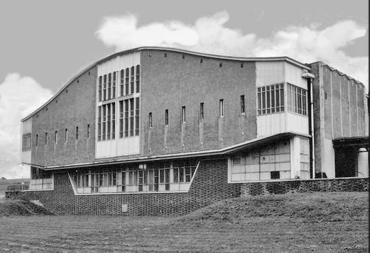
The church was designed in a very futuristic style which was perhaps too adventurous in the choice of materials and construction methods to survive into modern times. The building was demolished in the summer of 2021 after lying derelict and abandoned for a number of years.
Reclaimed timber, recovered from the two previous churches, has been utilised for internal furnishings of the new building.
The church is deemed to be of special architectural interest and has been designated as category "B" listed building by Historic Environment Scotland.
St Martin's closed in November 2010 and still lies abandoned and derelict after various schemes for alternative uses came to nothing. The presbytery is currently occupied as a residential care home.
The trapezoidal shaped building had an unconventional timber roof structure which provided the main source of natural light by way of glazed bow-string trusses. The roof�s unusual composition allowed the long-term rain penetration which contributed to the church's eventual demise. Rainwater formed numerous pools on the roof surface which had a badly designed drainage system.
There was a flat roofed concrete semi-circular apse to the rear containing the altar.
The adjoining presbytery, situated near the main entrance, is a two storey and basement building with a monopitched copper roof.
The building was built with facing brick around a reinforced concrete portal frame. It has a pitched slated roof. The main entrance to the church is situated at the north gable, contained within a contemporary styled concrete portico with attractive full-height glazing.
![]()
|
|
| |
|
|
||
|
|
All original artwork, photography and text © Gerald Blaikie
Unauthorised reproduction of any image on this website is not permitted.
