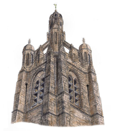
Drawing of the tower of Strathbungo Parish Church by Gerald Blaikie
Strathbungo and Crossmyloof originated as neighbouring villages situated to the south-west of Glasgow on the road to Pollokshaws. They were separated by a mere half mile of straight road and subsequent development has led to the present day districts being contiguous.
Description of Strathbungo and Crossmyloof from 'Glimpses of Old Glasgow', 1894
The name Strathbungo, which is pronounced as “Stra'bungo”, is thought to be a corruption of Strathmungo, after Glasgow's patron saint.
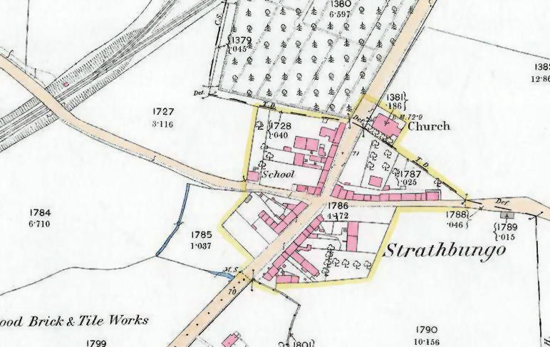
In the above map of Renfrewshire from 1820, Marchtown is shown on the western side of Pollokshaws Road at the junction with Nithsdale Road. The county boundary with Lanarkshire, to the north of the village, is coloured blue.
The boundary for the Renfrewshire part of Govan Parish is coloured red and the boundary for Cathcart Parish is green.
Stra'bungo had multiple identities in the early 1800's, being known as Marchtown, Strathmungo or Strathbungo.
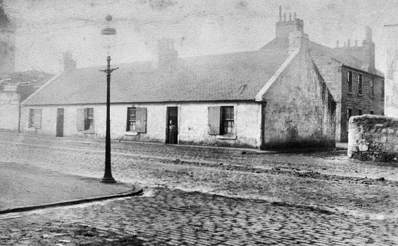
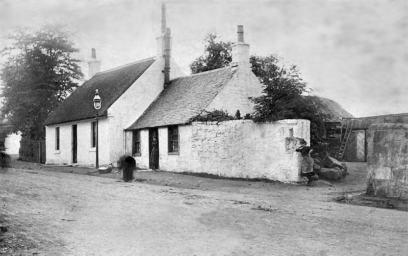
'Muirhouses' consisted on rows of single storey cottages situated a quarter of a mile from Strathbungo, on the the other side of the county boundary.
Muirhouses, near Strathbungo village
The extract below is from an Ordnance Survey Name Book from 1858 regarding Strathbungo and its immediate surroundings.
The entry for Strathbungo refers to "A small village, on the road leading from Glasgow to Pollokshaws". "In it is a handsomely built church which is in connection with the Parish Church of Govan. This church has got no Quoad Sacra district attached". Strathbungo also had "a school partly supported by the heritors". The Schoolmaster was named as Kenneth McKenzie.
The associated map, published after the completion of the above survey, shows the village of Strathbungo being situated on both sides of Pollokshaws Road, alongside Allison Street and Nithsdale Road. The railway at the top of the image is seen as it would have been about twenty years before the opening of Strathbungo Station, built to serve the commuters of the newly developed suburb.
Investigations carried out by the Glasgow Archaeological Society in 1890 suggest that the name Marchtown originated when the area was being developed by the Maxwells of Pollok, the feudal superiors. It appears that they did not like Strathbungo as a name and therefore called it Marchtown in the legal documents granting tenure to the new occupants. The title 'Marchtown' was used in the feuing plan which was prepared to accurately plot the available portions of land and the surrounding marches.
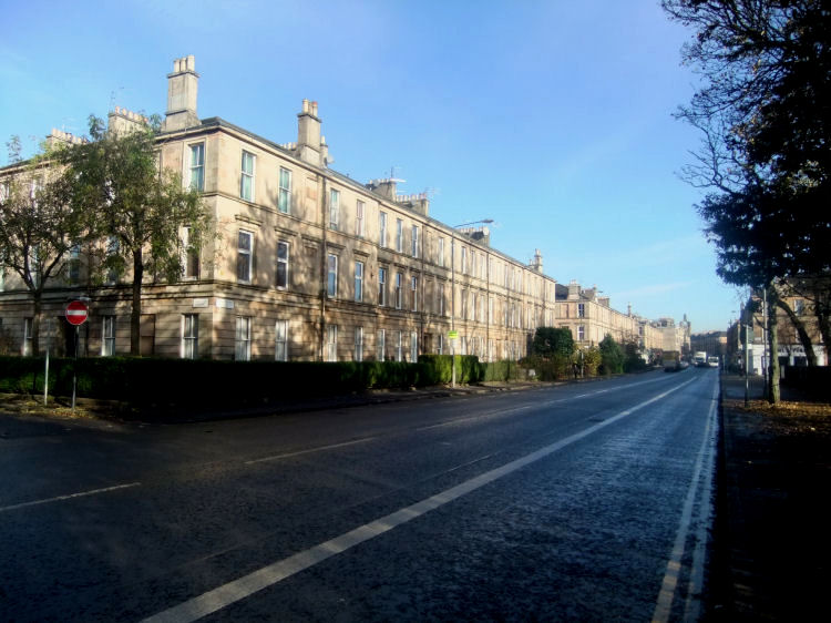
The extracts, below, from an 1833 directory show that the local societies used the name 'Marchtown' in their official titles but not for the place of residence of the officials, where 'Strathbungo' was preferred. This preference is continued today by the residents of the elegant terraces of Regent Park which were developed in the middle of the century to the south and west of the old village of Strathbungo.
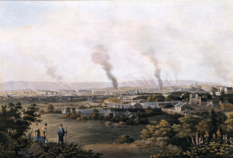
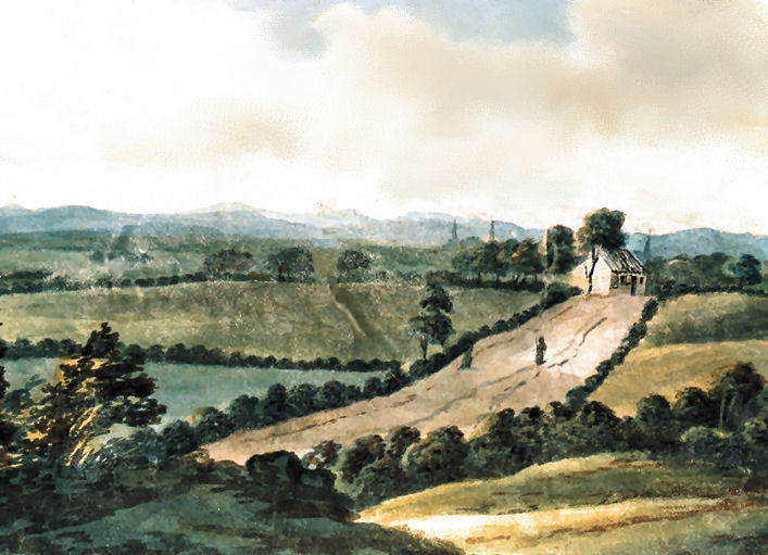
In this painting of Strathbungo from the early 1800's, the artist's foreground view is
from the bottom of Camphill near the present day entrance to Queen's Park at Balvicar Drive.
The church at the edge of the village can be seen to the right of the picture.
The grazing cattle would now be in the middle of the Queen's Park pond!
Painting of Strathbungo village
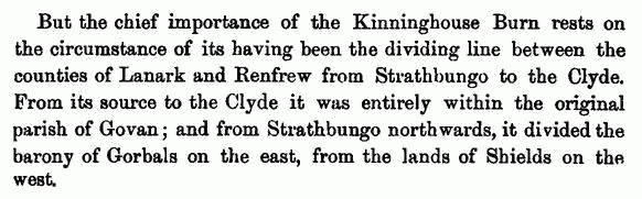
In the early 1800's the county boundary from Strathbungo to the Clyde was marked by the Kinninghouse Burn, which drained the extensive bogland of Shawmoss, which covered more than 150 acres of ground between Strathbungo and Haggs Castle on its western edge. The moss would have included all the flat land surrounding the railway stations at Crossmyloof and Maxwell Park, currently used for housing and sports fields. The map below shows the Kinninghouse Burn at the top of the page, flowing to the right from Strathbungo towards the Clyde. On the Lanarkshire side of the burn at the bottom of the map, you can see the Barony of Gorbals, which stretched all the way from the city centre to the boundary at the village of Strathbungo. There is a a dedicated section of this website covering the Origins & History of Gorbals .
Map showing Kinninghouse Burn separating the Barony of Gorbals, Lanarkshire, & the Lands of Shields, Renfrewshire
With the coming of carefully planned terraces of houses at Regent Park, a new sewer was constructed on a different line from the burn, passing through the centre of the new development. The flow of the burn was diverted at its source to connect with the new sewer.
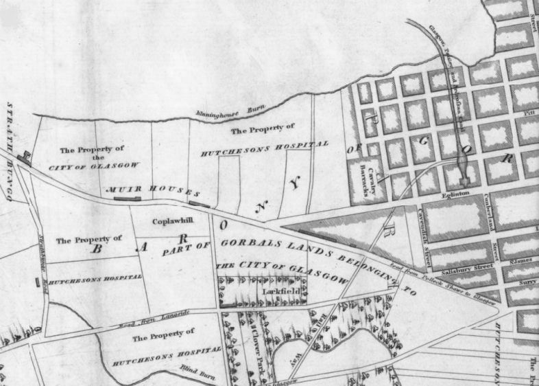
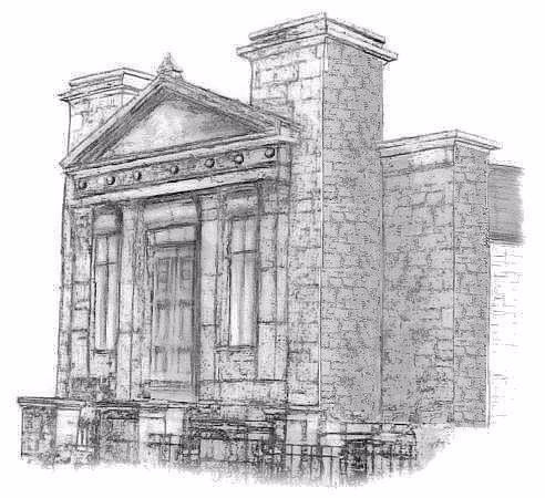
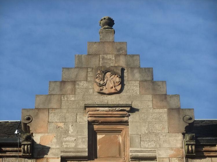
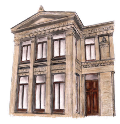
The original version of Strathbungo Parish Church occupied the same site on Pollokshaws Road as the present building. It was designed by architect Charles Wilson and opened in 1839.
Earlier version of Strathbungo Parish Church
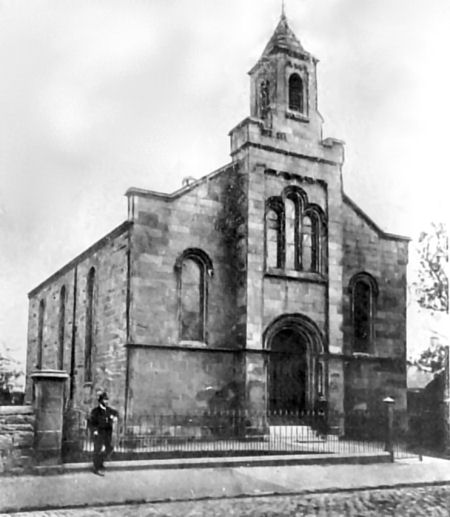
This sketch from 1884 shows the approaches to the village from the city, with Strathbungo Parish Church on the left. This church was replaced with a new building in 1888. A history of the churches on the site is included among the many spires illustrated in my Queen's Park Churches web page.
View of Pollokshaws Road from 1884, looking towards Strathbungo
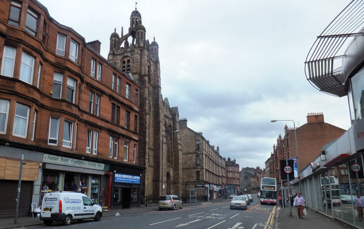
Same stretch of Pollokshaws Road with 1888 church, June 2014
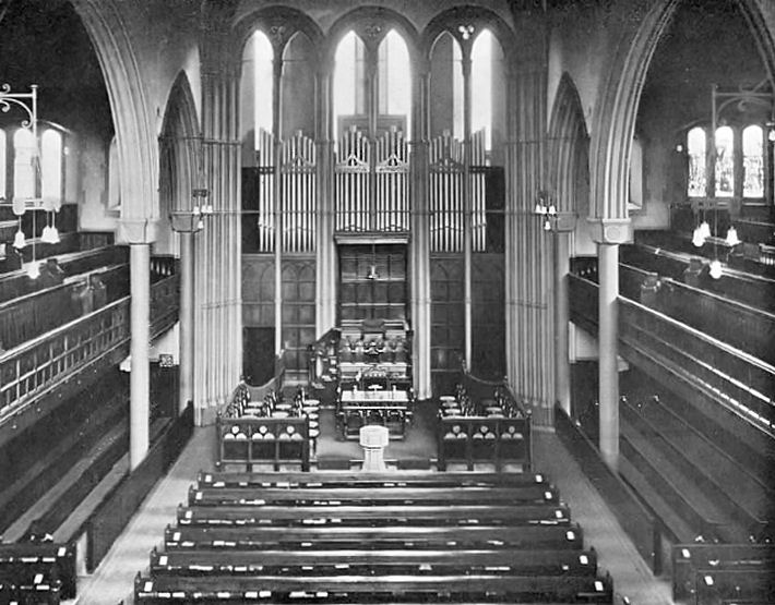
Interior view of later Strathbungo Parish Church
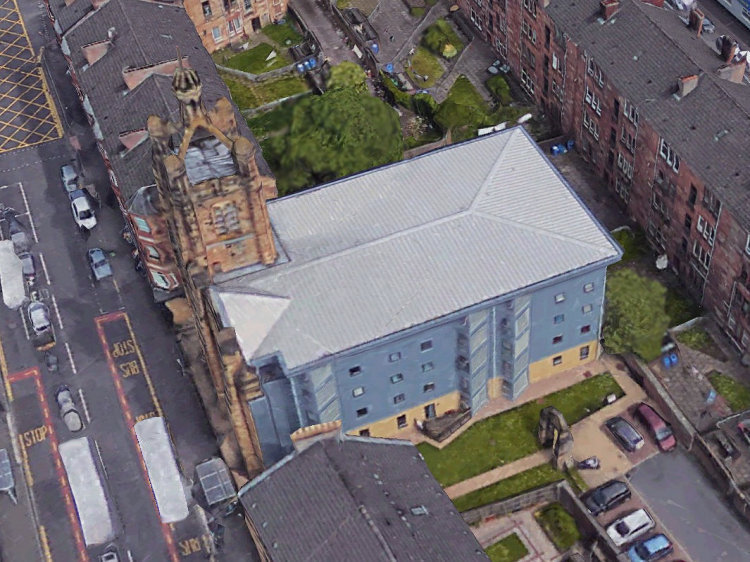
New building behind façade of Strathbungo Parish Church
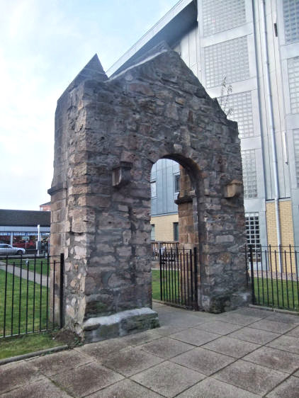
Surviving arched doorway to side of Strathbungo Parish Church
The ruins of Nithsdale Mission Hall, which was built for the congregation of Queen's Park U.P. Church, can be found in Nithsdale Drive adjacent to a deep railway cutting. The hall was designed by Alexander Skirving and completed in 1888. After a mysterious fire in July 2005 the building was reduced to a roofless ruin with an uncertain future.
Pencil sketch of Nithsdale U.P. Mission Hall
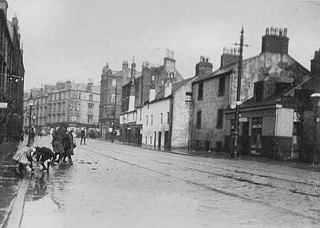
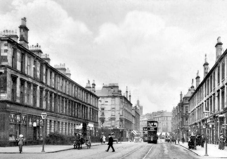
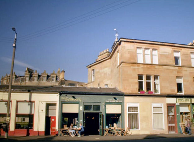
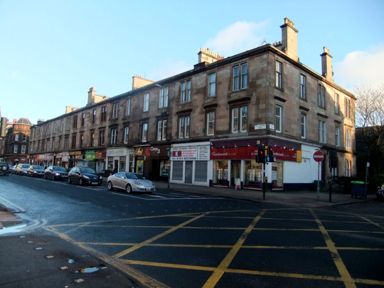
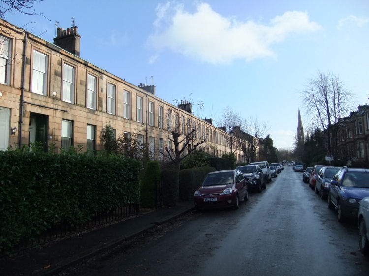
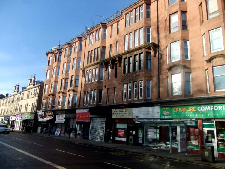
These photographs from c.1900 and 2014 show a stretch of Pollokshaws Road on the south side of the junction with Allison Street, looking towards the city centre. The balustraded red sandstone tenement at the corner remains as a recognisable feature. The site of the last remnants of the traditional houses in the village now contains the red sandstone block which has the 'Panda House' Restaurant and the 'Rum Shack' Public House. On the near side of the road you can see a pawnbrokers sign near the site of the Allison Arms.
Photograph of Pollokshaws Road, Strathbungo, c.1900, with children playing in a puddle
Photograph of Pollokshaws Road, Strathbungo, June 2014
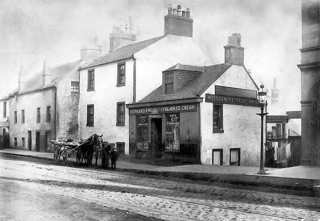
This photograph shows some of the shops and houses that were soon to replaced with the red sandstone tenement shown in the above view. You can get a glimpse of the arched window of the newly erected bank building which is now occupied as a charity shop by the Prince of Wales Hospice.
Photograph of Pollokshaws Road, Strathbungo, c.1900, with children running across the street
Photograph of shops and freshly whitewashed houses in Pollokshaws Road, Strathbungo, c.1900
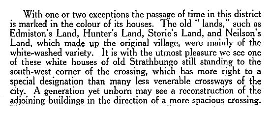
In the 1800's the traditional housing blocks of Strathbungo would not have had street names and numbers. They were identified by various "lands" named after the owners of the sites on which they were erected. The above photographs show some of these "lands", described in the article below as "mainly of the white-washed variety". The buildings are listed as Edmiston's Land, Hunter’s Land, Storie's Land and Neilson's Land. These unusual addresses crop up when looking through old registration documents for residents of the old Strathbungo village.
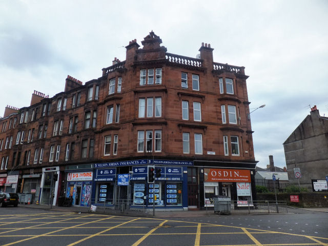
Balustraded red sandstone tenement block at corner of Pollokshaws Road and Allison Street
Aerial view of site of old village of Strathbungo, centred around junction of Pollokshaws Road and Allison Street
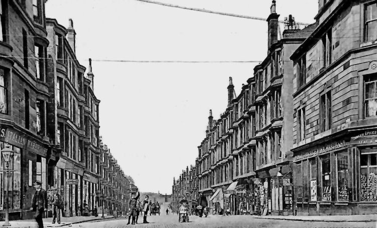
Early 20th century view of Pollokshaws Road, Strathbungo, from the corner of Regent Park Square
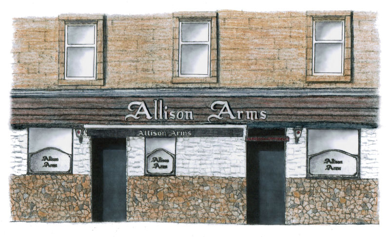
The unusual façade of the Allison Arms pub originated in the 1960's, during the time when John Flynn was the licensee and Bavarian style Bier Kellers were in fashion in Glasgow. It includes a “crazy paving” dado wall with white painted stuccowork above. The frontage is completed with a dark timber fascia with distinctive Gothic lettering displaying the pub's title.
Internally the pub has retained its old style gantries and bars.
Drawing of façade of Allison Arms, Strathbungo
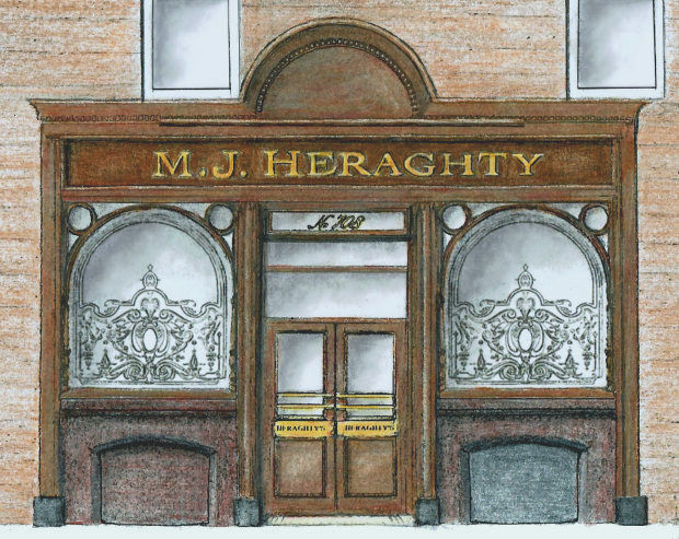
Heraghty's Bar, a short stagger along from the Allison Arms, has an attractive old-fashioned timber frontage echoing the traditional style of the pub's interior.
Drawing of façade of Heraghty's Bar, Strathbungo
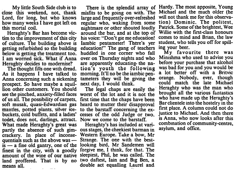
A humorous appreciation of Heraghty's along with its clientele and staff featured in Jack McLean's weekly column in the Glasgow Herald in September 1989 when the block was being refurbished. Jack, known as Glasgow's "Urban Voltaire”, regularly described Heraghty's as his "Little South Side club" in his witty rants of the 1980's and 1990's.
Extract from Glasgow Herald, 8th September 1989, with Jack McLean's take on Heraghty's Bar
Jack's 1989 nightmare vision of the future has been realised in the intervening period with the ongoing gentrification of Strathbungo's boozers which now provide a collective magnet for trendy types from far and wide.
At one time the Allison Arms and Heraghty’s didn't have a Ladies toilet between them but both pubs now have provided these modern luxuries, with the Allison's created from a single WC which formerly was an outside toilet entered from the common close next door. The female clients of Heraghty's had to wait until 1996 before any provision was made for their pressing needs!
Jack McLean in sunny Strathbungo, June 2019
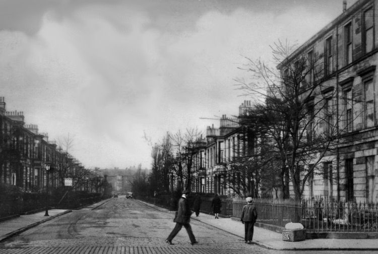
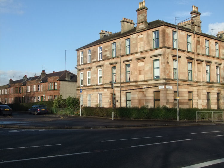
This view from the corner of Pollokshaws Road and Nithsdale Street shows the tenement block containing both Heraghty's and the Allison Arms. This is the block referred to by Jack McLean when it was being refurbished in 1989.
View from corner of Pollokshaws Road and Nithsdale Street, Strathbungo, 2016
The view below from c.1890 was taken from around the same spot as the modern photograph and shows the demolition of some of Strathbungo's old village buildings. The newly erected tenement block in the background still stands at the corner of Nithsdale Street and March Street, whose name is a reminder of the village's alternative title of "Marchtown". Strathbungo railway station can be glimpsed in the distance.
Demolition in progress at Nithsdale Street, Strathbungo, c.1890
This present day view shows the above tenement after renovation and restoration of the stonework.
Corner of Nithsdale Street and March Street with Police Station in middle of tenement block
Monogram of Renfrew County Council 'RCC' at former Police Station, March Street, Strathbungo
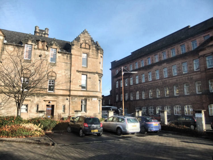
Shortly after Strathbungo became part of Glasgow in 1891 work began on the replacement Police and Fire Station in Craigie Street. The building was designed by the City Engineer, Alexander Beith McDonald and was erected in stages between 1892 and 1898. The complex was converted to 38 flats in the summer of 1994.
View of former Craigie Street Police Station and Strathbungo Public School
Strathbungo is noted for the density of licensed premises contained within such a small district. This is a direct result of its former marginal status.
Strathbungo was situated just outside the 'Dry Areas' which were created by the Glasgow-wide 'Veto Poll' of 2nd November 1920, which resulted in a a ban on the sale of alcohol in many of the surrounding districts from 1921 until the mid-1970's.
This protection from the evils of alcohol in surrounding neighbourhoods resulted in Strathbungo being overprovided with public houses and licensed restaurants, which continues to this day.
The popularity of the district for drinkers is shown in this Victorian description of the local inns.
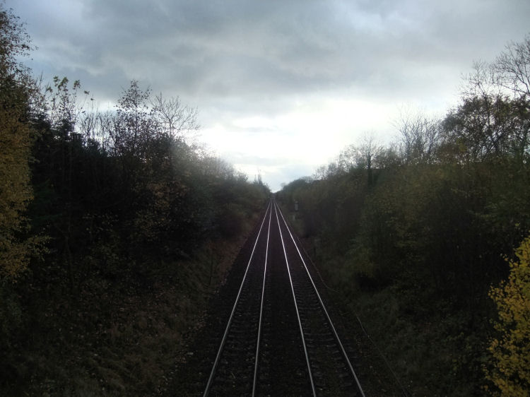
The Glasgow to Barrhead railway line opened in 1848, originally operating from Southside Station in the Gorbals and later from St Enoch Station. There is a full description of the development of the line at the Gorbals Stations page of this website.
Refurbished footbridge over railway at Strathbungo, 2019
The footbridge was dismantled on 8th January 2023 as part of the electrification programme for the Barrhead line. It was proposed to re-assemble the bridge in Brechin on a heritage railway project.
View from footbridge of the railway line running from Strathbungo towards Crossmyloof
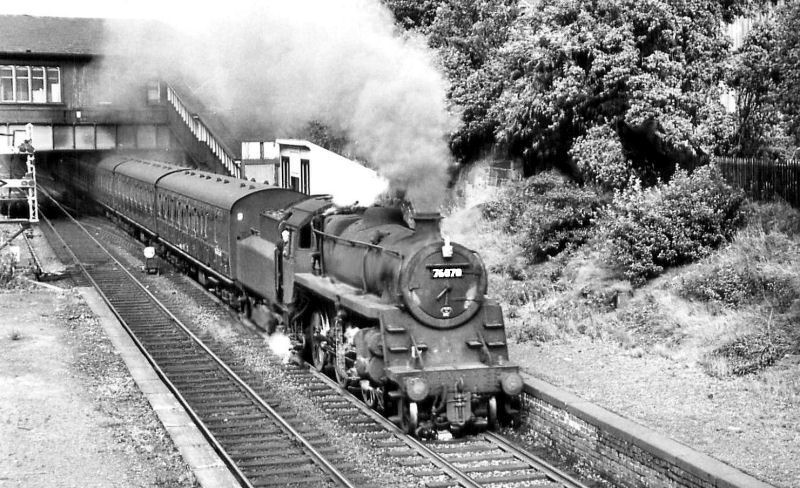
Strathbungo Station closed on 28th May 1962, the same day that the electric “Blue Trains” replaced the steam and diesel trains on the Cathcart Circle lines.
Steam train passing through Strathbungo Station
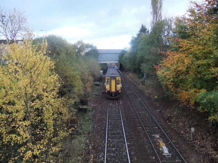
City bound deisel train passing site of former Strathbungo Station, 2012
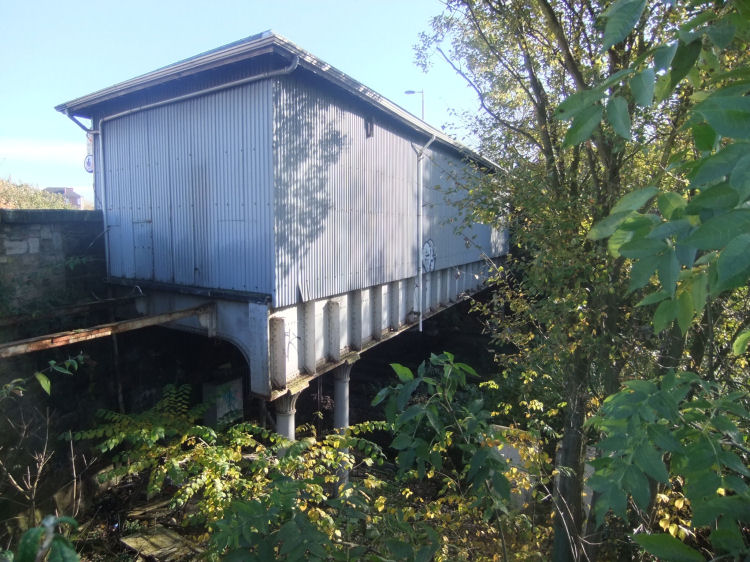
Former booking office at Strathbungo Station suspended on cast-iron columns
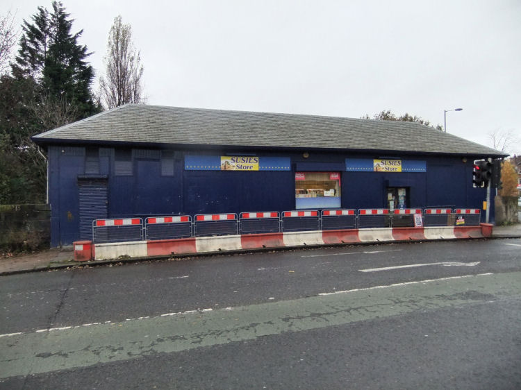
The former booking office, occupied for a long time as "Susie's Store", was removed in August 2022 as part of the works to replace the road bridge for the electrification of the Barrhead line.
Former booking Office for Strathbungo Station on road bridge at Nithsdale Road
The route of the 2014 Commonwealth Games marathon passed by many familiar landmarks in the city before reaching the former Strathbungo Railway Station.
Leading athletes of the the 2014 Commonwealth Games marathon passing Strathbungo Station
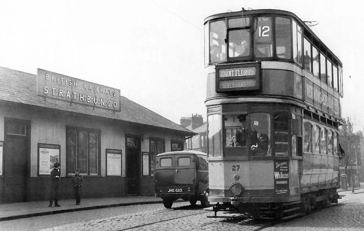
No. 12 tram passing booking office at Strathbungo Station
The No. 12 tram service was replaced by the No. 108 trolleybus service from 16th November 1958 on the route from Mount Florida to Paisley Road Toll, passing through Strathbungo via Allison Street and Nithsdale Street.
The service was replaced by the No. 68 motorbus on 3rd March 1967.
No. 108 trolleybus in Nithsdale Street, Strathbungo, en route to Mount Florida
This early 1960's view of Strathbungo Station shows a single-decker No. 108 trolleybus passing along Nithsdale Road en route to the Paisley Road Toll terminus by way of Shields Road.
A recent view of the same scene (below) shows very little change apart from the removal of the stairways leading down to the station platforms.
This view of Strathbungo junction from the Nithsdale Road railway bridge shows the various lines in the vicinity.
View of Strathbungo Junction looking towards the city centre
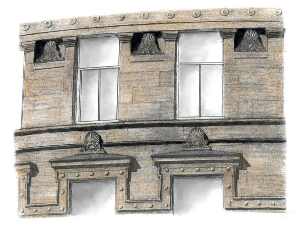
Drawing of details around windows of Salisbury Quadrant, Strathbungo
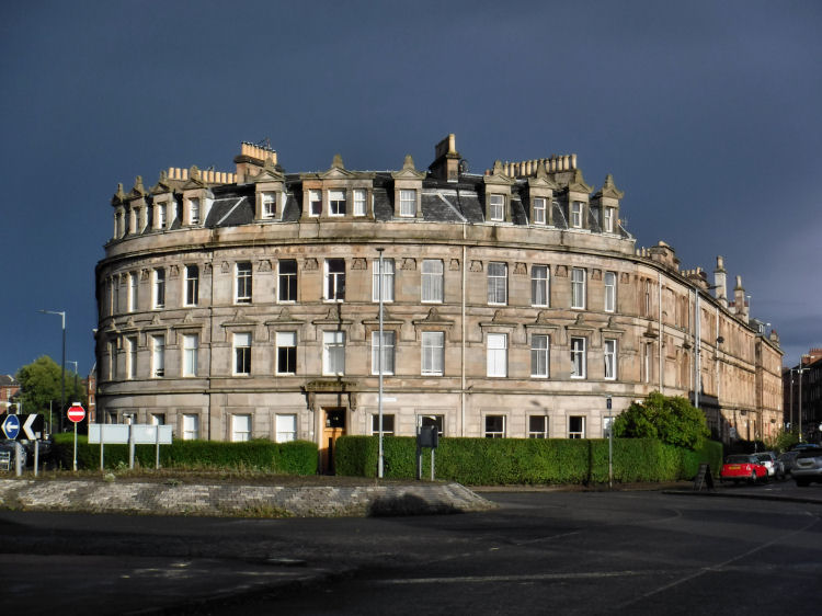
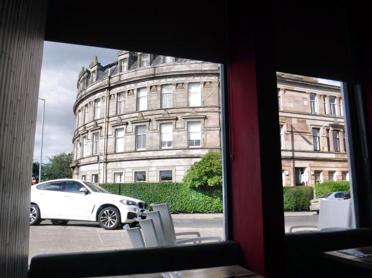
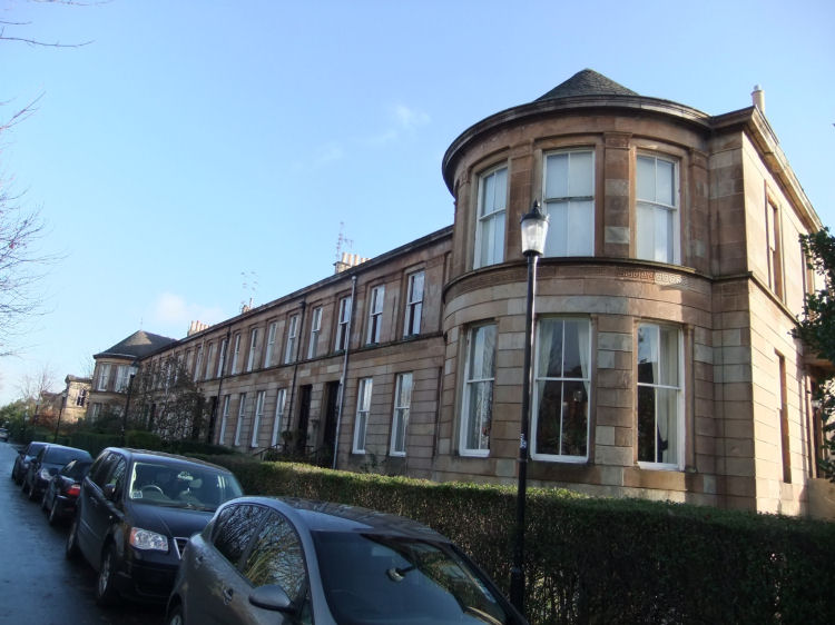
Strathbungo's grandest tenement is Salisbury Quadrant with a magnificent curved façade surrounding the junction of Nithsdale Drive and Nithsdale Street. It was finished a few years after the death of Alexander Thomson in 1875.
The narrow stretch of single storey retail units approaching the junction was used for the BBC drama series, "The Replacement", broadcast in early 2017. The Salisbury restaurant had two opposite entrances, allowing the characters to run straight through the bar to the exit at Nithsdale Street facing Salisbury Quadrant.
Still frame from "The Replacement", featuring the Salisbury Bar/ Diner
View of Salisbury Quadrant from window table at Salisbury Bar/ Diner
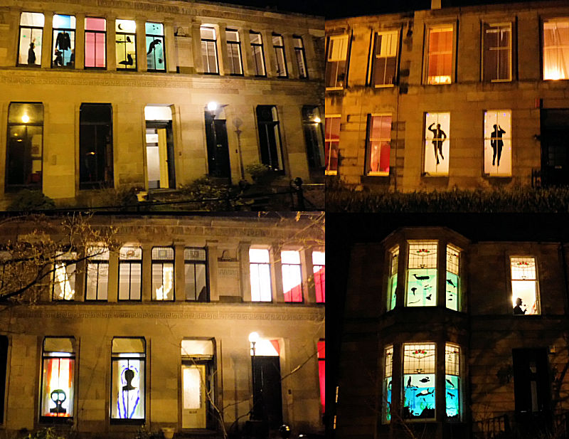
In February the local streets are brightened up with the "Strathbungo Window Wanderland" event provided by the residents of the area.
Collage of images from "Strathbungo Window Wonderland", February 2018
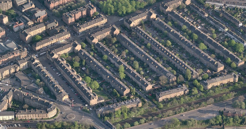
The boundaries of the Strathbungo Conservation Area were designated in 1973 and altered in 1978. It covers only the late Victorian additions to the district - the Regent Park development and Salisbury Quadrant. It excludes most of the buildings contained within the bounds of the old settlement.
Aerial view of Strathbungo Conservation Area
Drawing of Alexander Thomson's home at Moray Place, Regent Park, by Gerald Blaikie
Regent Park was a planned suburb which originated in 1859 on land adjacent to the railway to the west of Strathbungo village. As it progressed, the site of the Titwood Brick and Tile Works, to the south of the village, was cleared for development. The first terrace to be built in Regent Park was at 1-10 Moray Place, which was completed in 1861. This included Alexander Thomson's family home at No. 1.
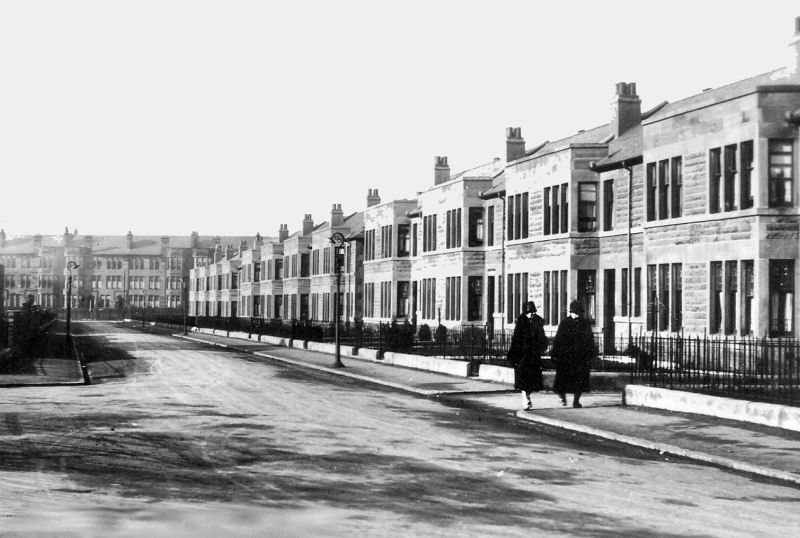
Before the 1891 absorption of the area by the City of Glasgow, the houses on the even numbered side of Pollokshaws Road , on the left of this photograph, were addressed as Regent Park Terrace, after which the Glasgow numbering system was adopted. The terraces connecting Regent Park Terrace with Moray Place were addressed as “Squares” - Regent Park Square, Queen Square and Princes Square (later renamed Marywood Square).
Looking down Pollokshaws Road with Regent Park Terrace to the left and Bute Terrace to the right
View of Bute Terrace, Strathbungo, looking south towards Queen's Park, 1903
The "Marchtown" bar/ bistro in the former Bute Terrace stretch of Pollokshaws Road, Strathbungo, 2017
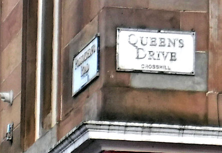
The street signs for Pollokshaws Road at Bute Terrace had the location "Crosshill" covered over after protests about the inaccuracy of the designation.
Section of Bute Terrace, Strathbungo, between Queens Drive and Torrisdale Street.
Queen's Drive sign at Bute Terrace retains the "Crosshill" label
Looking down Queen Square from Moray Place towards Pollokshaws Road
View of terrace at Moray Place, between Marywood Square and Queen Square
View of terrace at Moray Place, between Queen Square and Regent Park Square
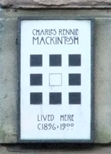
Glasgow's "other" famous architect also had connections with Regent Park, Strathbungo.
Plaque at Regent Park Square where Charles Rennie Mackintosh once lived
View of Regent Park Square looking towards Pollokshaws Road, c.1910
View of Marywood Square, when known as Princes Square, at corner of Pollokshaws Road, c.1930
Some of the land between Strathbungo and Crossmyloof was not developed until the inter-war era of the twentieth century when the red sandstone terraces to the south of Regent Park were built.
These later houses were included in the original Strathbungo Conservation Area, but removed when the boundary was revised in 1978.
Vennard Gardens, where Regent Park ends and 1920's development begins
Junction of Vennard Gardens (right) and Titwood Road (left) which leads to Crossmyloof Station
Newly built terraced houses in Vennard Gardens, immediately south of Regent Park
Inter-war terraced houses in Thorncliffe Gardens
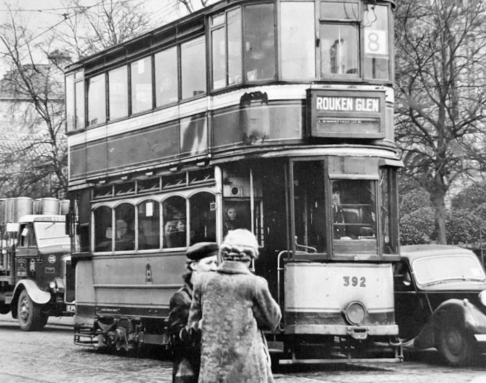
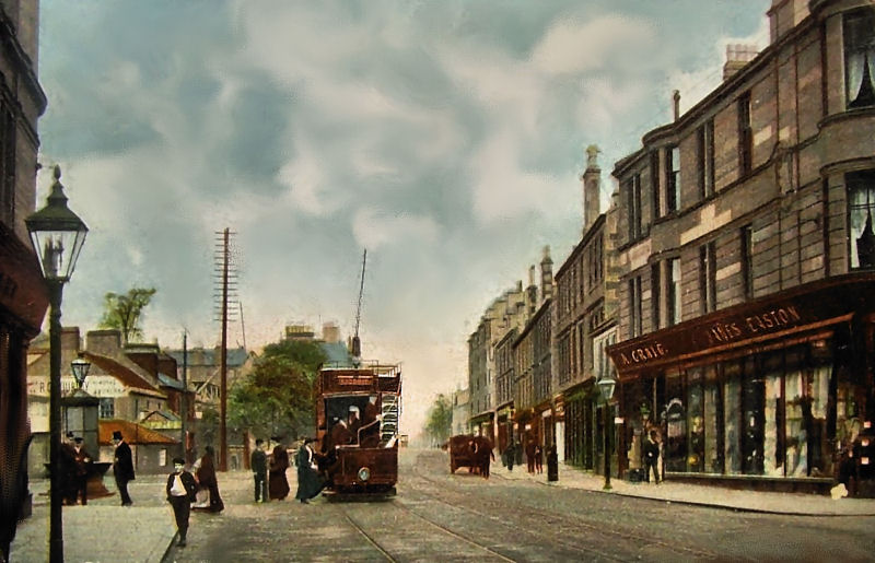
No.8 tram, bound for Rouken Glen, in Pollokshaws Road, Strathbungo, in the early 1950's
On the way to Crossmyloof, the undeveloped ground to the west of Pollokshaws Road was known as the "Lands of Westfield", while the ground on the eastern side was known as the "Lands of Camphill", later to become Queen's Park. Camphill House, which still stands within the park, is featured in the Langside and Battlefield page of this website.
Portions of the Lands of Westfield were available for speculative development when the above sale notices were published in 1881 and 1883.
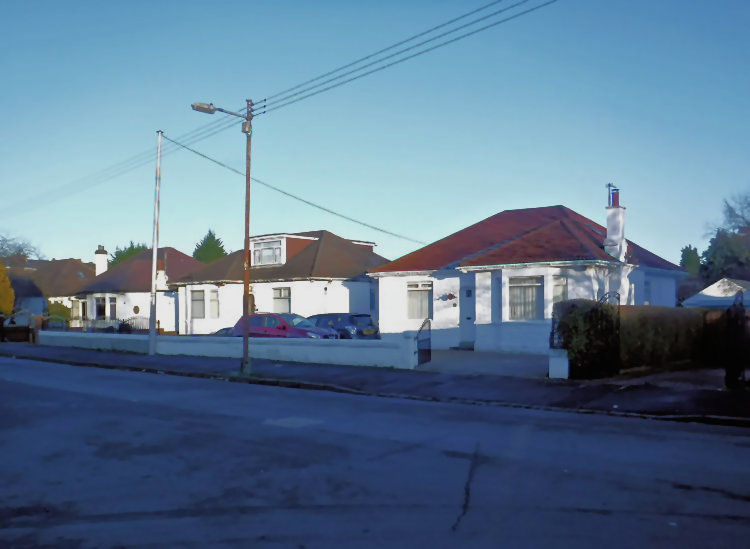
Many people now think of Crossmyloof as being the area of inter-war bungalows near Morrisons supermarket, which was built in and around the site of the old indoor ice rink.
Inter-war bungalows built on site of Shawmoss Farm, Crossmyloof
This old map dating from 1776 shows Langside as "Langton" and Strathbungo as "Marchton". Crossmyloof is unmarked as the small group of houses next to the 3 mile mark from Glasgow, down the hill from Langton.
The written description of the settlements along the road mentions Crossmyloof and also "Lanton" and the "River Earl", which was an alternative name for the White Cart Water in honour of Earl Cathcart, which was never widely adopted. These old forms can still be found in local place names such as Earlspark and Lanton Park on the other side of the Cart in Newlands.
This map from the late 1850's shows the built up settlement of Crossmyloof around the junction of Pollokshaws Road and Langside Avenue. Minard Road had yet to be formed and Westfield was primarily an area of orchards and nurseries used for cultivation of fruit, vegetables and flowers.
The last remnant of the old village to disappear was Westfield Lane, at the corner of Minard Road and Pollokshaws Road. This photograph shows a remarkable contrast between old and new, with the tramlines passing the quaint old hamlet with a billboard showing the way to the new Crossmyloof railway station.
George Muir, whose slater's workshop is shown in the photograph lived at Crossmyloof Buildings, showing that the terraces of Baker Street were not restricted just to the workers of Crossmyloof Bakery.
The map of Westfield Lane shown below was surveyed at the same time as the above photograph, between the opening of the new station in 1888 and the erection of the red sandstone tenement at the corner of Minard Road in 1893.
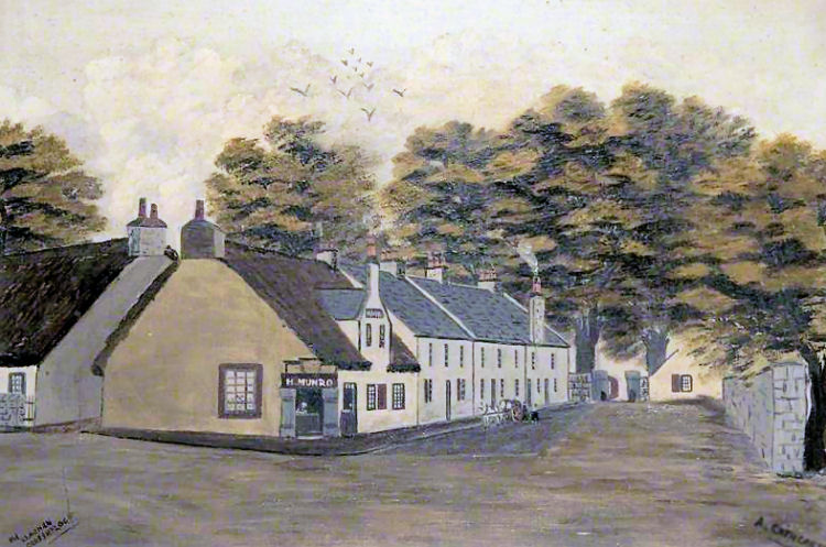
Earlier view of Westfield Lane, Crossmyloof
Painting of Westfield Lane, Crossmyloof
In this modern view Westfield Lane has been replaced by the red sandstone tenement blocks of Minard Road.
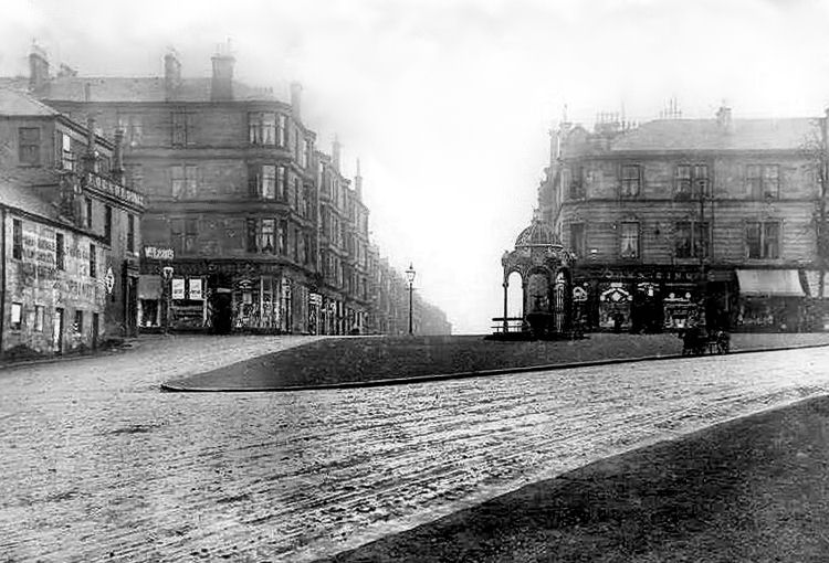
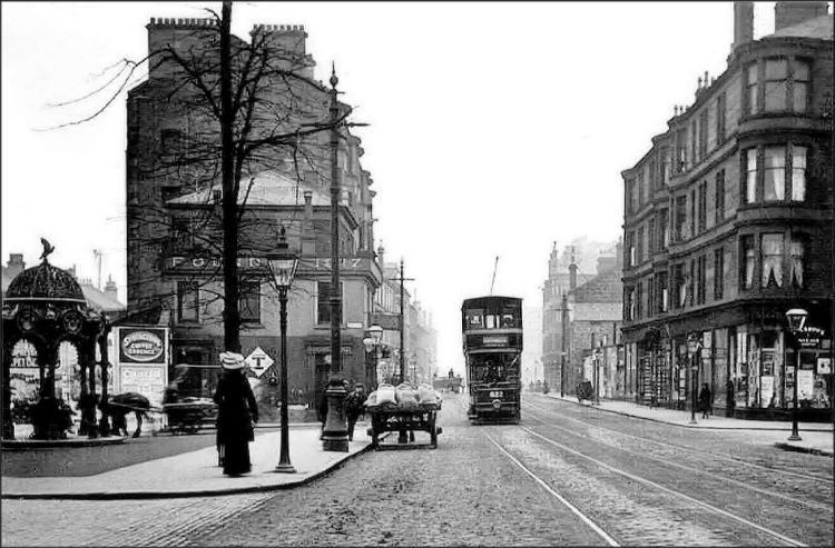
View of the site of Crossmyloof village, looking west
1905 view of the site of Crossmyloof village, before the Corona Bar opened in 1912
Corner view of Minard Road, Langside Avenue and Pollokshaws Road
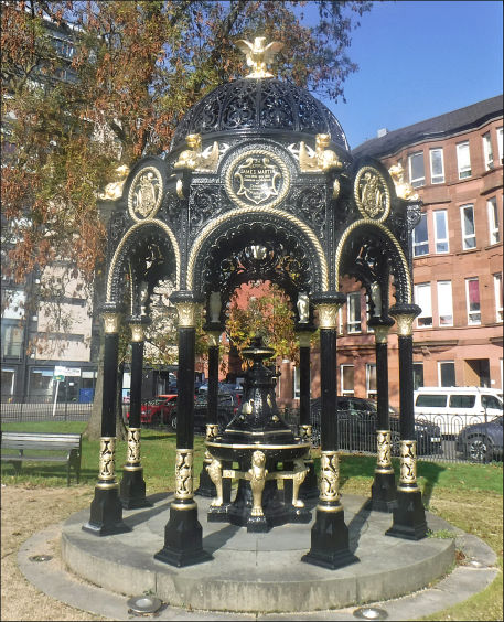
Bailie James Martin Memorial Fountain relocated from Crossmyloof to Glasgow Green
Early 20th century view of Minard Road
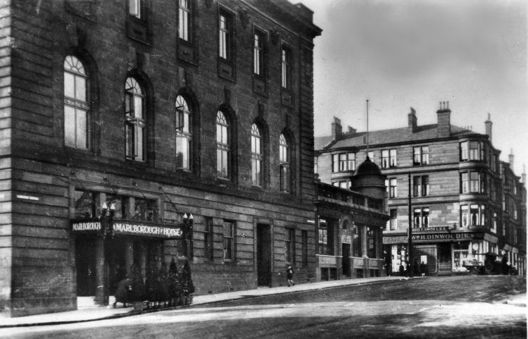
View of Marlborough House and Corona Bar
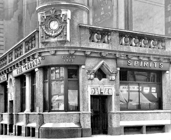
The Corona Bar occupies a fine corner position at the site of the old Crossmyloof village. It was built in 1912, replacing an earlier hostelry shown in the Victorian maps. The nature of the site allowed a highly decorative single storey design by James. H. Craigie of the Glasgow architectural practice, Clarke and Bell.
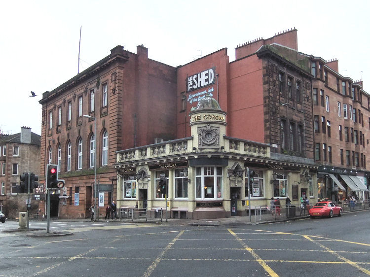
View of Corona Bar from western side of Pollokshaws Road
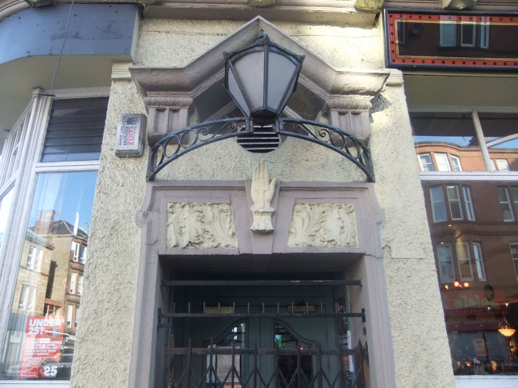
Over each of the entances of the Corona Bar there are plaster images of a hand with a cross in the palm.
There have been lots of suggestions as to the origins of the name Crossmyloof with the most popular being associated with either Mary Queen of Scots or local gypsies.
Hand with a cross in the palm at Corona Bar, Crossmyloof
Camphill Gate and nearby Springhill Gardens were the highest residential blocks in Glasgow when erected between 1904 and 1906. These five storey blocks were designed by John Nisbet without the luxury of elevators, which would be expected in any modern development of this height. Camphill Gate was built in front of the buildings of Neale Thomson's Crossmyloof Bakery so there were no back greens for the use of the occupants. The architect got round this problem by providing a flat roof laid out as a drying area. The roof was fabricated by the Albion Fireproof Construction Company.
Camphill Gate, Pollokshaws Road, with iron ballustrade at flat roof
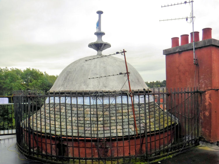
Cupola viewed from flat roof at Camphill Gate
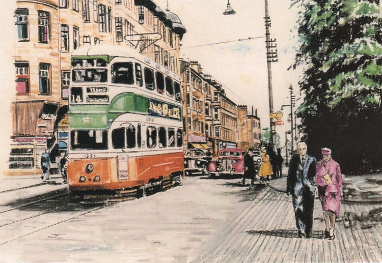
1950's sketch of tram passing Camphill Gate
1950's view of platforms at Crossmyloof Railway Station
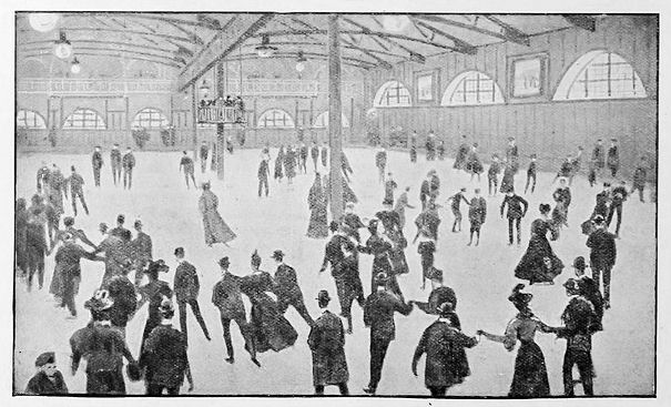
In the twentieth century Crossmyloof was best known for its indoor ice rink, which opened in 1907 and closed in 1986. It was situated in what is now the site of Morrisons supermarket.
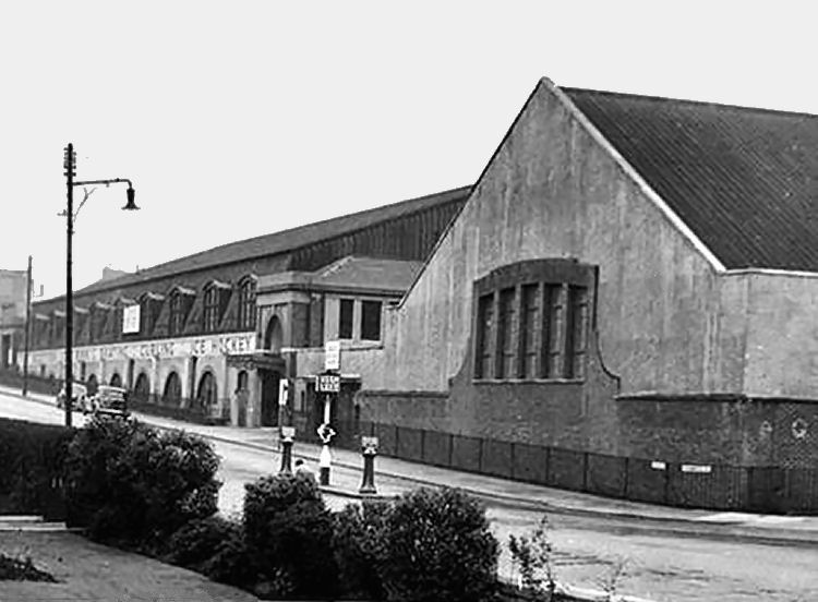
Exterior view of Crossmyloof Ice Rink
The article below gives a brief description of the ice rink a few years after it had opened.
Inside Crossmyloof Ice Rink, 1909
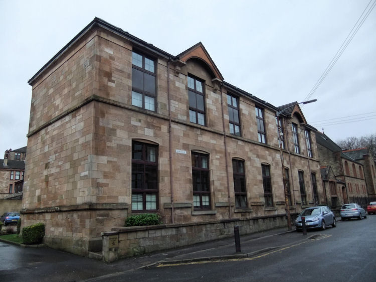
Crossmyloof Public School was built in 1877 in Deanston Drive, which was called Stevenson Drive at the time.
Former Crossmyloof Public School, Deanston Drive
Premises of R.G. Gourlay, Pollokshaws Road, Crossmyloof
The picture above shows the premises of R.G. Gourlay, Cabinermaker and Upholsterer, at the corner of Moss-side Road and Pollokshaws Road. This location would now be considered as being in Shawlands rather than Crossmyloof, but the Post Office Directories of the time list the workshops as being located at "1118 Pollokshaws Road, Crossmyloof". The buildings were demolished shortly after the photograph was taken to become the the site of Shawlands Parish Church, which was built as Shawlands United Free Church in 1901.
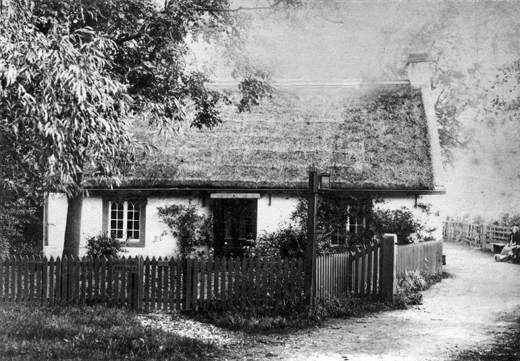
Moss Side Cottage, Crossmyloof, on site now occupied by Shawlands Academy
The popular modern suburb of Shawlands has no real history, consisting until the late 19th century of rows of cottages along Pollokshaws Road and Kilmarnock Road and a few buildings situated on farmland between the village of Crossmyloof and the town of Pollokshaws. The familiar tenement blocks and villas which characterise the area originated as speculative developments from around 1880. The church buildings situated in these new developments are featured in the Shawlands & Pollokshaws Churches page of this website.
The map below from c.1860 shows the parish boundary between Cathcart and Eastwood, with Crossmyloof and Langside within Cathcart Parish and Shawlands in Eastwood Parish.
Mid-19th century map showing cottages at Shawlands south of parish boundary from Crossmyloof
Early 20th century view from Shawlands Cross looking towards Crossmyloof and the Queen's Park
Old Toll House at Crossmyloof, near the junction of Pollokshaws Road and Kilmarnock Road
This earlier view of Shawlands is from close to where the railway bridge now crosses Pollokshaws Road at Shawlands Station. It shows a single dwelling house surrounded by fields and hedgerows. The spires of the churches of Pollokshields and Queen's Park can be seen in the distance.
View of Shawlands on the road from Pollokshaws to Crossmyloof, 1832

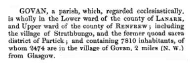
An alternative name for Strathbungo was Marchtown, derived from the marches or divisions occurring very near to each other at the site. The marches for the counties of Renfrew and Lanark and the marches for the parishes of Cathcart and Govan surrounded the village.
To complicate matters even further, the parish boundaries of both Cathcart and Govan did not follow the county boundaries and adjacent parts of the parishes could be situated in either Lanarkshire or Renfrewshire!
This extract from Lewis's Topographical Dictionary of Scotland (1846), gives Strathbungo a special mention as being situated in the parish of Govan.

Crossmyloof was within Cathcart Parish near the yellow boundary of Eastwood Parish, were Shawlands was situated.
This extract from Duncan's Itinerary of Scotland (1823) shows all the settlements on the road from Glasgow to Pollokshaws, separated by fractions of a mile, including Strathbungo and Crossmyloof.
The syllables of Crossmyloof are deliberately hyphenated as if to make a point about the derivation of the name.
"Loof" or "luif" is old Scots for the palm of the hand, so a literal translation would be "Cross my palm".


The adjacent Titwood Brick & Tile Works was described as "A small Brick work on the farm of Titwood". A short time after this survey was completed the ground occupied by the brickworks would become the site of the Regent Park development, pioneered by Alexander "Greek" Thomson.


Around 1825, large scale drainage operations took place, reducing the volume
of water in the Kinninghouse Burn and sending a considerable flow westward to the White Cart Water in what is now Pollok Country Park. Prior to this the marshland was often flooded, used for curling in winter and providing a habitat for numerous species of water fowl.
After the drainage of the surrounding land, the source of the burn was situated closer to Strathbungo. It had then been reduced to a small stream that could dry up in prolonged summer droughts.
On the other side of Strathbungo village the burn had flowed towards the Clyde to what would later become Springfield Quay. It was culverted in stages, linking up with the extensive public sewers of the developing industrial districts of Tradeston and Kinning Park.
The drawing shows the tramlines on Pollokshaws Road in an age before the electrification of Glasgow's tram system. At this time the city had an extensive horse-drawn tram service.


The former Strathbungo Station can be spotted in the background at the top of the road.
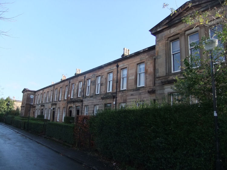
The red sandstone Strathbungo Public School was designed by the Glasgow architects, John Gordon and Thomas Baird. It is still in use for its intended purpose, being currently known as St Bride's Primary School.
Only 4 of the city's 37 wards voted for alcohol free status - Whiteinch in the West End and 3 neighbouring wards in the South Side; Cathcart, Camphill and Pollokshields. The licences for all the pubs in these wards were not renewed after they expired on 28th May 1921.
Cathcart, Newlands and Muirend lost 5 public houses while
Camphill, Langside, Battlefield, Crosshill and Mount Florida lost 17 public houses. The Pollokshields ward, which included the Regent Park terraces around Strathbungo, lost 8 public houses.
True to form, however, the ward boundaries around the old village of Strathbungo were all over the place, creating an oasis for the drinking man! Most of the tenemental part of Strathbungo was included in the Kingston ward which had voted for 'No Change' to its licensed status, retaining all of its 84 pubs. Some of the streets approaching Victoria Road were included in the Govanhill ward, which had voted for a partial limitation in licensing.
The line was in operation for nearly thirty years before the opening of the station at Strathbungo in 1877, and 40 years before the opening of Crossmyloof Station in 1888. The first stop on the route in 1848 was at Pollokshaws (now Pollokshaws West) Station.
As well as Barrhead, current destinations for trains passing through are East Kilbride, Kilmarnock and Carlisle.


The commuters of Strathbungo were able to use the faster, cleaner, new trains from either Queen's Park or Pollokshields West stations, which are both nearby.
The photograph below shows the leading pack of the mens' race when they were about twenty minutes away from the finishing line in Glasgow Green. The eventual winner of the race, Michael Shelley of Australia, can be seen nearest the old station among the three leading runners.
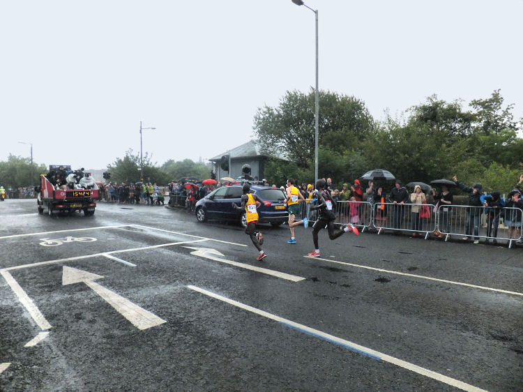


On the far left there is a city bound electric train coming from Pollokshields West Station on the Cathcart Circle.
In the centre there is a Barrhead bound train from Central Station approaching the site of the former Strathbungo Station.
On the far right is the line to the old St Enoch Station heading towards Gorbals Junction at Cumberland Street where it once met up with the City Union Line. The track is still usable as far as Larkfield Bus Depot where it joins the route to Polmadie Rail Depot which runs parallel to the West Coast Main Line and the M74 extension.

The Alexander Thomson's Terraces section of this website contains a detailed photographic study of 1-10 Moray Place.
The blocks on the eastern side of Pollokshaws Road, shown to the right in the photograph, were known as Bute Terrace, Strathbungo. For some inexplicable reason Bute Terrace is included within the boundaries of Crosshill Conservation Area, an area with which it has no natural affinity.


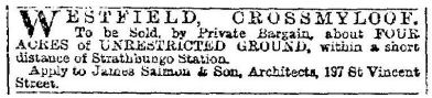
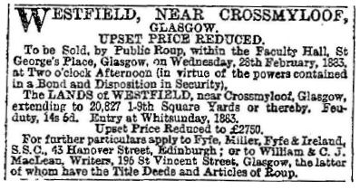
The "short distance to Strathbungo Station" was mentioned because Crossmyloof did not have a station until 1888, while Strathbungo station had opened in 1877, a few years before the advertisement was published.
The advertisements were for plots of land on the western side of Pollokshaws Road upon which sandstone tenements in and around Minard Road would subsequently be erected. Minard Road first appears in the Post Office Directory for 1893/ 1894 along with the even numbered (south-eastern) side of Westfield Street, which was subsequently renamed as Westclyffe Street.
These houses were actually built on the fields of Shawmoss Farm, which was sequestrated in 1926 following the bankrupcy of its owner, Alexander Aitkenhead. The dairy attached to the farmhouse, run by Mrs Annie Aitkenhead also went out of business and the land was acquired for residential development.

Crossmyloof Bakery, owned and operated by Neale Thomson of Camphill, was the largest bakery in the vicinity of Glasgow at the time and some of the original buildings from the bakery are still standing. In Baker Street, Crossmyloof Buildings provided terraced accomodation for the bakery workers. The terraces, which were designed by Alexander "Greek" Thomson, were demolished in 1964.
The Cart Forge was situated between Baker Street and Cathcart Place, the local name for this section of Pollokshaws Road. It was used for the fabrication of axles for railway wagons.


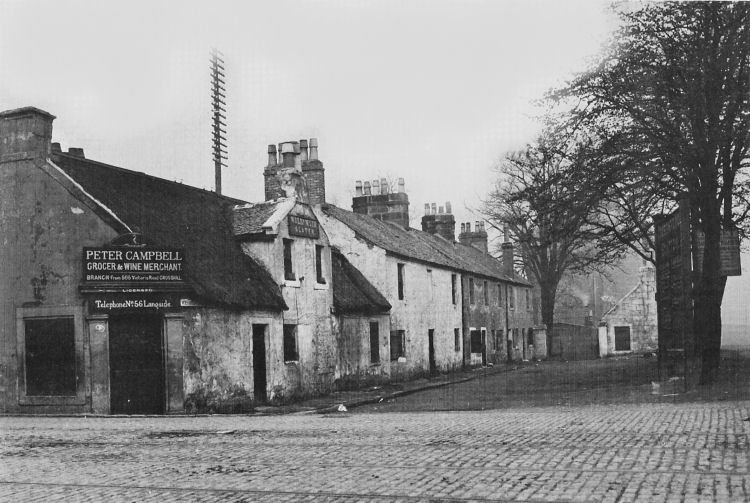
The location of the photograph at Westfield Lane was confirmed by the street sign at the corner, under the thatched roof of Peter Campbell's shop.
![]()
It is remarkably accurate, down to the position of the trees, the tramlines and even the billboards.


On the opposite corner stands Campvale Buildings which were built in 1873, about 20 years before the formation of Minard Road.


The school building was converted into 16 flats in the summer of 1996.


![]()
|
|
| |
|
|
||
|
|
All original artwork, photography and text © Gerald Blaikie
Unauthorised reproduction of any image on this website is not permitted.
